

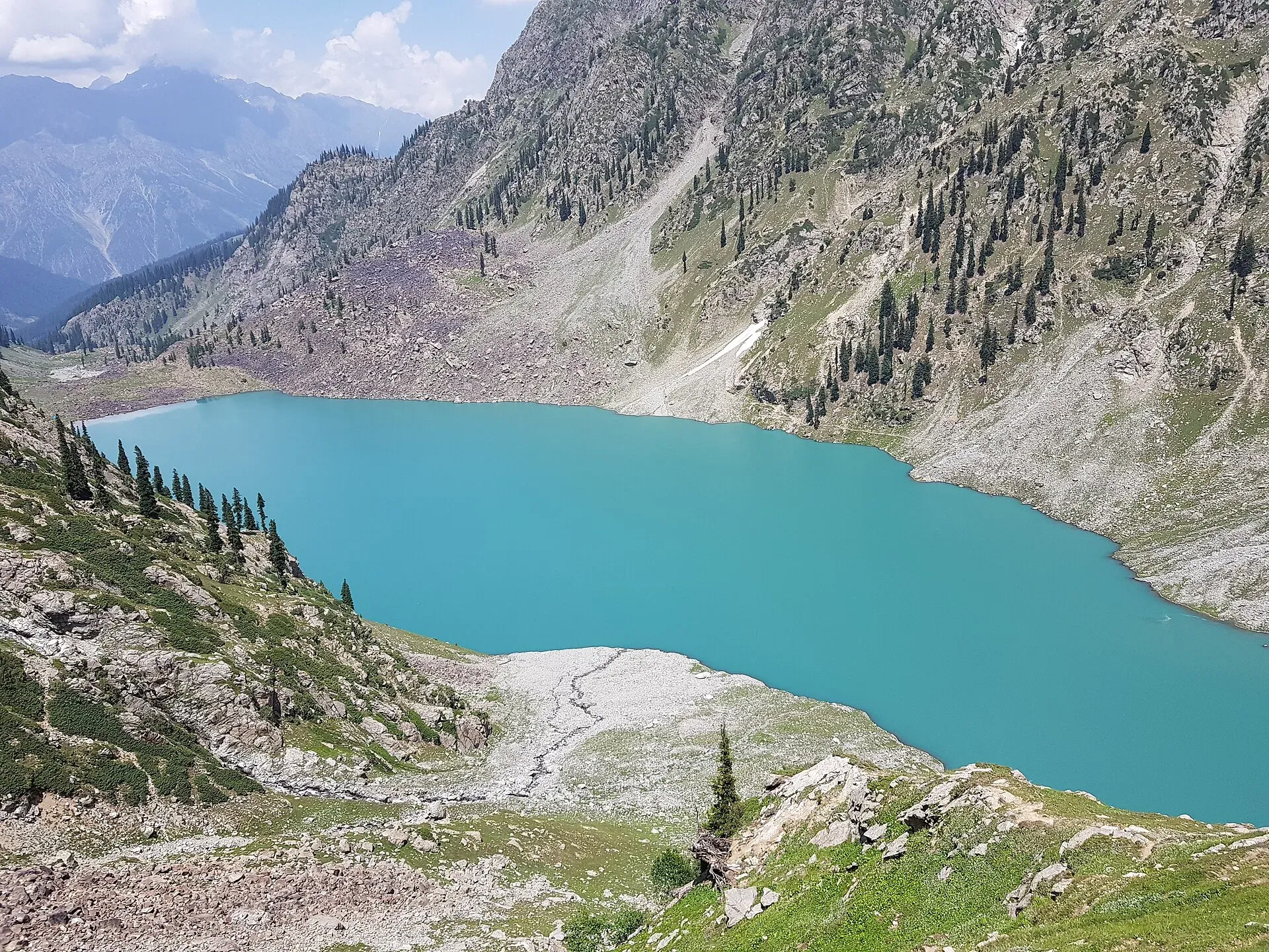
Photo: Kmbilall, with thanks · CC BY-SA 4.0 · via Wikimedia Commons · temporary stand-in photo

Kundol Lake
A glacial lake at about 3,030 m above Utror in Swat, reached by a 4x4 track to Ladu and then a hike of around four to six hours.
Overview
Kundol Lake (also spelled Kandol or Kundol) lies at about 3,033 m in the mountains north of Utror, in the Utror valley of Upper Swat. It is a glacial lake, fed by meltwater from Hindu Kush glaciers and by springs, and its outflow forms the Utror stream, a tributary of the Swat River. The lake is about 19 km from Kalam by Wikipedia's figure, though the route by road and trail is much longer than that line suggests.
Wikipedia gives the lake about 1.5 km in length and about 1 km in width. A separate Wikipedia article on the Utror valley gives 2,900 m for the lake, so treat 3,033 m as approximate.
Utror, the valley below, is a union council in Upper Swat at about 2,300 m, 16 km from Kalam. It is home to the Gawri people, one of the communities of Swat Kohistan, and it is bordered by the Bhan valley to the east, Upper Dir to the west and Gabral to the north. The Badogai Pass links Utror to Upper Dir.
It is a destination for people who want the quiet side of Swat. The walk follows the stream through forest and past small waterfalls.
Plan your visit
- Nearest town
- Utror
- Getting there
Drive from Mingora to Kalam first (see Swat and Kalam). From Kalam a rough road runs to Utror and a link road continues to Ladu, which is the jeep end. Use a 4x4. More
Best months
Jul – Sep
- Kundol Lake
- Related places nearby: Utror Camping (Swat), Kalam, Utror and Gabral, Kalam, Mahodand Lake, Izmis Lake, Swat Valley, Spin Khwar Lake
What to see and do
- The hike. From the end of the jeep road at Ladu the trail follows the stream and takes about four to six hours on foot according to Wikipedia, depending on fitness and conditions. Dawn (24 November 2016) reported about an hour and a half from Ladu on the alternative trek used after the 2010 floods, so allow for a wide range.
- Camping on the shore. The lake bank is used as a summer campsite by trekkers.
- Nearby lakes. Izmis Lake is in the same valley system. Mahodand Lake is in the neighbouring Usho valley.
- Utror village. The village and its camping area are covered on the Utror camping page.
When to visit
The lake is accessible only in summer. Roads and trails are snowed in for much of the year. July to September is the most reliable window; the snow line can sit low well into June.
Where to stay and eat
Stay in Kalam or Utror, where there are guesthouses and camps. At the lake, there are no facilities. Carry a tent, food and water treatment, and follow leave-no-trace rules. Get permission from local people at Utror or Ladu before camping, and use a local guide if you do not know the trail.
Good to know
- Vehicle: An unpaved road goes from Kalam to Utror and a link road continues to Ladu. A 4x4 is needed.
- Altitude: At over 3,000 m, take it slowly on the first day.
- Weather: Storms build in the afternoons. Streams swell with meltwater, so cross early in the day.
- Fees: Any camping, guide or jeep charges are set locally. Current fees will be added soon.
- Mobile coverage: Do not expect any beyond Utror.
Travel advice
Ask the district administration or local police about current conditions before you go. For foreign visitors: the UK FCDO advises against all travel to Swat (advice updated 27 October 2026, checked 16 November 2026). Read the live advice before you plan.
Highlights
- Glacial lake at about 3,030 m
- Hike of 4 to 6 hours from Ladu along a stream
- Forest, waterfalls and summer camping
- Quiet alternative to the busier Swat lakes
Getting there
Drive from Mingora to Kalam first (see Swat and Kalam). From Kalam a rough road runs to Utror and a link road continues to Ladu, which is the jeep end. Use a 4x4. From Ladu, walk up beside the stream to the lake in about four to six hours. Return the same way. There is no public transport past Kalam.
Tips
- Hire a local jeep from Kalam or Utror to Ladu and start walking early
- Carry a tent and all food; there are no facilities at the lake
- Go with a local guide if you are unsure of the trail
- Check the road and weather in Kalam before leaving
Photos we still need: the forest trail and waterfalls between Ladu and the lake; Ladu village. Send us yours
Sources and last checked
Last checked Confidence medium3 sources4 still to check
- Last checked
- Method
- Desk research from published sources
- Confidence
- medium
- Checked by
- trek.pk research team
Researched from published sources; not yet checked on the ground by our team. Spot something out of date? Report a mistake.
Sources
- Kundol Lake · Wikipedia · checked
- Cold weather? No problem: Trekkers continue heading to Kandol Lake in December · Dawn, 24 November 2016 · checked
- Utror Valley (Wikipedia) · Wikipedia · checked
Still to be checked on the ground (4)
- Hike time from Ladu: Wikipedia says four to six hours; Dawn (2016) says about 1.5 hours; unresolved
- Current state of the road from Kalam to Ladu (Wikipedia: unpaved to Utror, 4WD, link road to Ladu; Dawn 2016: alternative trek bumpy and 'far from perfect'; on the ground)
- Camping rules at the lake (Wikipedia only says the shore is used as a summer campsite)
- Lake height: 3,033 m (Wikipedia, Kundol Lake) against 2,900 m (Wikipedia, Utror Valley)
Nearby and related

Kundol Lake Hike from Utror

Utror Camping (Swat)
Summer tent camping in the Utror valley above Kalam in upper Swat, near the meadows and the track to Kundol Lake. UK advice is against all travel to Swat.

Kalam, Utror and Gabral
The head of the Swat valley: Kalam town where the Ushu and Gabral rivers meet, with Ushu forest, Utror and Kundol Lake, Gabral, and jeep tracks to Mahodand Lake.

Kalam
The last large town in the upper Swat Valley, at about 2,000 m where the Ushu and Gabral rivers meet. Kalam is the base for Ushu, Utror, Mahodand Lake and Kundol Lake.

Mahodand Lake
A cold trout lake at about 2,865 m in the Usho valley above Kalam, reached by a rough 4x4 track of around 40 km. Open in summer only.
Izmis Lake
A high glacial lake above the tree line, south-west of Utror in Swat. A jeep track ends at Loypanrghalay and the lake is a 3 to 6 hour walk beyond.

Swat Valley
A long green river valley in northern Khyber Pakhtunkhwa, with Gandhara Buddhist sites, orchards, hill towns and the road up to Kalam. Check the current security advice before you plan a trip.
Spin Khwar Lake
A lake north of Kundol Lake and east of the Utror valley in Swat Kohistan, reached from the Ladu valley or from Kundol. Steep, basic, and for experienced trekkers.

Swat and Kalam
A 4-5 day road trip from Islamabad up the Swat valley by the M-16 and N-95 to Mingora, Madyan, Bahrain and Kalam, with Mahodand Lake and Ushu forest in summer.