

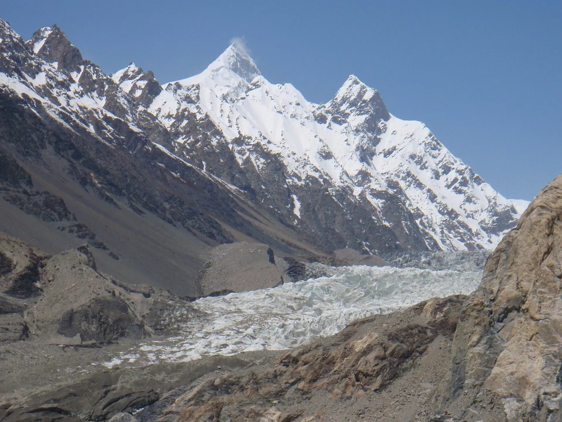
Photo: Raki_Man, with thanks · CC BY 3.0 · via Wikimedia Commons · temporary stand-in photo

Shispare
Shispare (7,611 m) is the high peak in the Batura Muztagh seen above Passu and the Passu Glacier. It was first climbed in 1974 by a Polish-German expedition.
Overview
Shispare (also written Shispare Sar) is 7,611 m high, the 38th highest mountain in the world, with a prominence of about 1,241 m. It is in the Batura Muztagh, the westernmost sub-range of the Karakoram, above Passu in Gojal, upper Hunza. The Hunza River curves round the south-eastern, eastern and north-eastern sides of the range, and Shispare rises above its western bank.
Plan your visit
- Nearest town
- Passu
- Getting there
Passu is on the Karakoram Highway in Gojal, upper Hunza. Shispare is seen from the village and from walks above it. More
Best months
Jun – Sep
- Shispare
- Related places nearby: Passu, Passu Glacier, Passu Sar, Batura Glacier, Gojal and Shimshal, Hunza Valley
The peak in the landscape
The mountain drops steeply on its north, east and south sides and has a large, steep north-east face. Karimabad, at about 2,060 m, is only about 13 km away, so the peak stands roughly 5,550 m above the town. It is part of the most south-easterly group of the Batura Muztagh, together with Pasu Sar, Ultar, Hunza Peak and Ladyfinger Peak. The Batura Wall, the highest part of the range, lies to the west.
First ascent and later climbs
A Polish-German Academic Expedition led by Janusz Kurczab made the first ascent on 21 July 1974. It was the first major peak in the Batura Muztagh to be climbed. The climb took about 35 days. The team went up the Passu Glacier to the east ridge and fixed about 1,500 m of rope. Seven climbers reached the top. Heinz Borchers, a member of the expedition, died in an avalanche while the team prepared a second summit push.
A Japanese university club spent almost two months on the mountain in 1989 and turned back at about 7,200 m. A Japanese club made the second ascent on 20 July 1994 by the same route. In 2017 Kazuya Hiraide and Kenro Nakajima climbed the previously unclimbed north-east route in alpine style, which won the Piolets d'Or. Wikipedia, citing the Himalayan Index, records no other ascents or attempts.
What to see and do
- Avdegar: the view west from this walk takes in the Ghulkin, Passu and Batura glaciers, with Shispare and the Batura peaks above. See the Avdegar trek.
- Patundas: a hill walk with wide views of the Hunza mountains. See the Patundas trek.
- Passu: the village sits below the peak, and the Passu Cones and Passu Glacier are close by.
When to visit
The valley walks are listed for about June to September.
Where to stay and eat
Passu and nearby Gojal villages have guesthouses and camping; Karimabad and Aliabad have more hotels.
Good to know
Climbing context. Shispare is a technical expedition peak for experienced, well-equipped mountaineers only. It is not a trekking peak and this page does not describe a climbing route. Climbing needs an expedition permit from the Gilgit-Baltistan authorities, arranged through a licensed Pakistani operator. No permit fees are quoted here; ask the operator for the current rules. It needs fixed-rope or alpine-style skills and glacier experience.
Getting there safely. For foreign visitors: the UK FCDO (updated 27 October 2026) advises against travel on the Karakoram Highway between Mansehra and Chilas but does not name Gilgit-Baltistan as a whole. Ask your operator which route they use.
Highlights
- 7,611 m peak in the Batura Muztagh
- First climbed in 1974 by a Polish-German team
- Seen above the Passu Glacier
- Visible from the Avdegar and Patundas walks
Getting there
Passu is on the Karakoram Highway in Gojal, upper Hunza. Shispare is seen from the village and from walks above it.
Tips
- You can see Shispare without any mountaineering, from Passu village.
- Morning light is usually clearest.
Photos we still need: Shispare seen from Passu or the Avdegar walk (section: The peak in the landscape); Passu Glacier approach used on the 1974 ascent (section: First ascent and later climbs). Send us yours
Sources and last checked
Last checked Confidence low2 sources3 still to check
- Last checked
- Method
- Desk research from published sources
- Confidence
- low
- Checked by
- trek.pk research team
Researched from published sources; not yet checked on the ground by our team. Spot something out of date? Report a mistake.
Sources
- Shispare (Wikipedia) · Wikipedia · checked
- Pakistan travel advice: warnings and insurance (updated 27 October 2026) · UK FCDO · checked
Still to be checked on the ground (3)
- Coordinates are Wikipedia's for the peak
- Best season to view from Passu (trek pages give June to September)
- Current royalty and permit rules (not confirmed from an official source)
Nearby and related

Avdegar

Patundas

Passu
A Wakhi village in Gojal beside the Passu Glacier, below the jagged Passu Cones (Tupopdan, 6,106 m). Known for Hussaini Suspension Bridge, glacier walks and Batura views.
Passu Glacier
A glacier south of Passu village in Gojal that you can see from the KKH and reach on a short walk. It lies below Passu Sar and has been retreating, so its length depends on the source.
Passu Sar
Passu Sar (7,478 m) is the high point of the Passu massif in the Batura Muztagh, above Passu village and the Passu Glacier in Gojal. The date of its first ascent is disputed.

Batura Glacier
About 57 km long, the Batura is one of the longest glaciers outside the polar regions. Its snout is close to the KKH in Gojal, and a five-day trek leads beside it to Guchesham beneath the Batura Wall.

Gojal and Shimshal
Upper Hunza: Gulmit, Ghulkin, Passu and Sost on the Karakoram Highway, with big glaciers and the Passu Cones, plus the remote Shimshal valley, its Wakhi village and its mountaineering community.

Hunza Valley
A long Karakoram valley on the Karakoram Highway, with Karimabad, Baltit and Altit forts, Ganish village and Attabad Lake, below Rakaposhi and Ultar Sar. About 100 km from Gilgit.