

Photo: Mhtoori, with thanks · CC BY-SA 4.0 · via Wikimedia Commons · temporary stand-in photo

Hindu and Jain Heritage
Katas Raj in the Salt Range, the Jain temples of Nagarparkar and Hinglaj Mata: a journey through Pakistan's Hindu and Jain heritage with history, pilgrim quotas and current safety advice.
Customise this route Change the dates, stops and how you travel in the Road Trip Planner.
The story
Hindu and Jain heritage in Pakistan is both ancient and living. The 2023 census counted 5,217,216 Hindus, 2.17 per cent of the population, most of them in Sindh (about 4.9 million). Tharparkar has the largest number of any district, over 811,000, and Umerkot is the only Hindu-majority district (54.66 per cent in the 2023 census and 52.15 per cent in 2017, per Wikipedia). The Hinglaj Yatra in Balochistan is described as the largest Hindu pilgrimage in the country.
Katas Raj
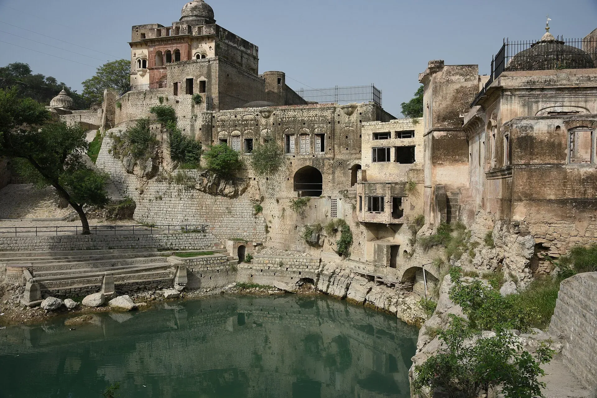
Katas Raj lies in the Salt Range of Chakwal District, at about 610 m, with a sacred pond. The Puranas say the pond formed from Shiva's tears after the death of his wife Sati. The Mahabharata places the Pandava brothers here during their exile. The oldest temple, Temple B in the Satghara group, dates to the late 6th century CE. Temple A dates to the 10th century CE, and the Odi Shahi dynasty built temples from the mid-7th to the 10th century. Maharaja Ranjit Singh visited in 1806, December 1818 and 1824. Restoration began in 2006. The pond dried up in 2012 and 2016, the Supreme Court took notice in 2016, and in May 2018 it ruled that cement factories must source water elsewhere and pay Punjab for what they draw. Wikipedia says floods damaged the temples in July 2025, but a Dawn headline it cites says the complex stood intact, so the extent of any damage is unclear.
The complex is a group of temples joined by walkways around the pond. The pond covers about two kanals and 15 marlas, with a maximum depth of 20 feet (Wikipedia). The Satghara group, the oldest, lies south-west of the pond. The Ramachandra temple is a double-storied building with eight rooms on the ground floor, and the Hanuman Mandir stands on the western edge of a raised enclosure. A Shiva temple sits on a square platform near the Satghara group, and the fort-residence of the Sikh general Hari Singh Nalwa overlooks the complex from a small hill. Shikharas, the tower-like tops of the temples, have been added from 2017 onward.
Katas Raj hosts Maha Shivaratri, and Hindu pilgrims have come since before Partition. Indian pilgrims were barred in 1965 and again after the 2008 Mumbai attacks, and Pakistani Hindus resumed the festival in 2010. The site is near Kallar Kahar, in the Choa Saidan Shah area, and is linked to the M-2.
Nagarparkar and the Thar
Nagarparkar is a tehsil at the foot of the Karoonjhar Mountains in Tharparkar, eastern Sindh. In 2017 about 63.6 per cent of its people were Hindu, and Wikipedia puts the town about 16 km from the Indian border, which is outside the 5-mile band in the UK FCDO advice, though parts of the Karoonjhar hills may be nearer. The Gori Temple was built in 1375 to 1376: marble, in Gujarati style, with three mandaps and 52 domes in an Islamic style, and with the oldest Jain frescoes in the northern subcontinent. At Bhodesar there are three ruined temples, the oldest from about the 9th century and the others from 1375 and 1449. Tradition dates the three Viravah temples, about 15 miles north of Nagarparkar, to 456 CE. The Bhodesar Mosque was built in 1505 by Sultan Mahmud Begada of Gujarat and shows Jain influence in its central dome. The area was a major Jain pilgrimage place until the 19th century, and the remaining Jains left after 1947. Pakistan placed Nagarparkar on UNESCO's tentative list as a cultural landscape in 2016. The Churrio Jabal Durga Mata Temple draws about 200,000 pilgrims for Shivratri.
Mithi and Umerkot. Mithi, the headquarters of Tharparkar District since 1990, is about 278 km east of Karachi (Wikipedia). In the 2023 census Hindus made up about 70 per cent of the taluka, and the town has one of the few Hindu majorities in Pakistan. The local language is Dhatki, close to Sindhi and Marwari, and traditional mud-brick architecture survives in the town. The Thar is dry and water is scarce. The Shiv Parvati Temple is in Mithi. Mithi is the usual overnight stop between Umerkot and Nagarparkar.
Hinglaj Mata
Hinglaj Mata is a cave temple in a narrow gorge inside Hingol National Park, in Lasbela, Balochistan, about 19 km inland from the Arabian Sea. It is one of the 51 Shakta pithas. The annual four-day Hinglaj Yatra is held in April, and local Muslims call the shrine Nani Mandir. We do not plan a visit to Hinglaj; see the safety section.
The shrine is a cave on the west bank of the Hingol River. On the way pilgrims visit the Chandragup mud volcano, which Hindus worship as an embodiment of Shiva called Baba Chandragup. On the third day of the yatra, priests recite mantras and bless the offerings. Pilgrims usually offer three coconuts, and many bathe in the river first. Wikipedia reports about 300,000 participants in the latest year it cites, from Pakistan and India, with Hindus from the Thar the largest group. Pilgrim groups have traditionally set out from the Nanad Panthi Akhada in Karachi. Wikipedia gives the distance from Karachi as about 328 km, a drive of around four hours on the Makran Coastal Highway, which replaced a desert walk of more than 150 km from the nearest road. Our own routing gave 240 km to the shrine area, so the two figures differ. We do not plan a visit to Hinglaj; see the safety section.
Journey stages
Two journeys cover most of the sites. Times are OSRM estimates for a car without stops, not timetables.
- Katas Raj from Islamabad. About 153 km, roughly 1 hour 45 minutes by road, using the M-2 and local roads in the Salt Range. It is a day trip, and Kallar Kahar is nearby.
- Karachi to Nagarparkar. Karachi to Umerkot is about 311 km (about 3 hours 50 minutes). Umerkot to Mithi is about 90 km (about 1 hour 50 minutes), and Mithi to Nagarparkar is about 132 km (about 2 hours). The total is about 531 km, so most visitors split it with a night in Mithi. Allow extra time on the desert roads.
- Hinglaj. Not planned; see the safety section.
Timeline
- 456 CE: Traditional date for the Viravah temples.
- Late 6th century CE: Oldest Katas Raj temple.
- 9th century CE: Oldest Bhodesar temple.
- 1375 to 1376: Gori Temple built.
- 1505: Bhodesar Mosque built.
- 2006: Katas Raj restoration begins.
- 2016: Nagarparkar placed on UNESCO's tentative list.
- 2025: Pakistan issues visas to 154 Indian Hindu pilgrims for Katas Raj; floods damage the temple in July.
What you will see
- Katas Raj: the pond, the main temple complex and the separate Satghara group, which has seven temples of which five survive, in a style like Kashmiri temples.
- Nagarparkar: the Gori Temple, the Bhodesar temples and mosque, and the Viravah temples.
- Umerkot: a fort said to have been built by Rana Amar Singh in the 11th century. In 1746 Noor Mohammad Kalhoro built a fort on the site of Akbar's birth, which is now open land.
Etiquette
Take your shoes off before temple precincts and dress modestly. Do not touch deities, offerings or sacred objects. Ask before photographing worshippers or rituals. Treat ruined Jain temples as holy ground. Do not climb on them, remove fragments or write on walls. Respect the Katas pond: do not litter or wade in it. Be sensitive about food; many Hindu and Jain visitors are vegetarian.
Pilgrim information
The Evacuee Trust Property Board lists Hindu yatras for pilgrims coming under the bilateral arrangements: Katas Raj in February or March and in October (quota 200, 5 days each) and the Shadani Darbar at Hayat Pitafi, Mirpur Mathelo, in November or December (quota 400, 10 days). Katas Raj hosts Shivratri, and in 2017 about 200 Indian pilgrims attended the festival. The ETPB arranges reception, accommodation and security for these pilgrims; ask it for details. Its shrines page gives only months, not dates, and its news list to 14 November 2026 has no notice of 2027 yatra dates or quotas.
When to go
October to March. Summer is very hot at Nagarparkar and Katas Raj. The Hinglaj Yatra is in April.
Entry fees
Fees may apply at Katas Raj and Nagarparkar; current fees will be added soon.
Highlights
- Katas Raj Temples, Chakwal
- Gori Temple and the Jain temples of Nagarparkar
- Bhodesar Mosque and Karoonjhar hills
- Hinglaj Mata (advised against at present)
Stops
- Katas Raj TemplesFrom Islamabad (OSRM estimate); Salt Range
- UmerkotFrom Karachi (OSRM estimate); Hindu-majority district
- Mithi89 km from Umerkot (OSRM estimate)
- Nagarparkar: Gori Temple, Bhodesar, Viravah132 km from Mithi (OSRM estimate)
- Hinglaj Mata (not planned)From Karachi by OSRM; Wikipedia gives about 328 km; Balochistan: all travel advised against
km: distance from the start along the route.
Numbers follow the stops in order. The map shows the stops, not the road itself.
Day by day
Day 1 · Islamabad to Katas Raj
Drive 153 km to Katas Raj. See the pond, the Satghara temples and the main complex. Stay at Kallar Kahar or Chakwal, or return the same day (another 153 km).
Day 2 · Return to Islamabad
Return by road. This is also a good day to visit the lake and Salt Range stops covered elsewhere.
Day 3 · Fly to Karachi (or travel by rail)
Karachi is 1,417 km from Islamabad by road (16.5 hours by OSRM), so a flight is best. Check flights and trains.
Day 4 · Karachi to Umerkot
Drive 310 km to Umerkot, a Hindu-majority district. Visit the fort where Akbar was born on 15 October 1542.
Day 5 · Umerkot to Nagarparkar via Mithi
Drive 89 km to Mithi and 132 km on to Nagarparkar. Roads in Tharparkar are long and quiet, so carry water and fuel.
Day 6 · Nagarparkar: Gori, Bhodesar and Viravah
See the Gori Temple, the Bhodesar temples and mosque and, if roads allow, the Viravah temples about 15 miles north. The Karoonjhar hills are nearby.
Day 7 · Nagarparkar to Umerkot
Drive 207 km back to Umerkot (direct, by OSRM).
Day 8 · Umerkot to Karachi
Drive 310 km to Karachi.
Road conditions
- Islamabad to Katas Raj: M-2 and a Salt Range road; paved.
- Karachi to Umerkot: paved highway.
- Mithi to Nagarparkar: paved but long and quiet; fuel is scarce.
- Times: OSRM drive times are optimistic and exclude stops, traffic and checkpoints.
Fuel and services
Fuel and hotels in Islamabad, Chakwal, Karachi, Hyderabad and Umerkot. Mithi and Nagarparkar have basic hotels and few services. Carry water and cash.
Where to stay, eat and fuel up
Places to stay
- Avari Towers KarachiCall Avari Towers KarachiMap of Avari Towers Karachi in Google Maps
- Pearl Continental Hotel, LahoreCall Pearl Continental Hotel, LahoreMap of Pearl Continental Hotel, Lahore in Google Maps
- Avari Hotel LahoreCall Avari Hotel LahoreMap of Avari Hotel Lahore in Google Maps
- Serena HotelCall Serena HotelMap of Serena Hotel in Google Maps
- Islamabad Marriott HotelCall Islamabad Marriott HotelMap of Islamabad Marriott Hotel in Google Maps
- Mövenpick KarachiCall Mövenpick KarachiMap of Mövenpick Karachi in Google Maps
Places to eat
- The Monal IslamabadCall The Monal IslamabadMap of The Monal Islamabad in Google Maps
- Tehzeeb Bakers Blue AreaCall Tehzeeb Bakers Blue AreaMap of Tehzeeb Bakers Blue Area in Google Maps
- TKR 3Call TKR 3Map of TKR 3 in Google Maps
- Port Grand - KarachiCall Port Grand - KarachiMap of Port Grand - Karachi in Google Maps
- Kolachi RestaurantCall Kolachi RestaurantMap of Kolachi Restaurant in Google Maps
- Savour FoodsCall Savour FoodsMap of Savour Foods in Google Maps
Essential services fuel stations, mechanics, banks, pharmacies and hospitals and clinics
Fuel
- PSO Petrol Pump (Stadium Service Station)Call PSO Petrol Pump (Stadium Service Station)Map of PSO Petrol Pump (Stadium Service Station) in Google Maps
- Attock Petrol PumpMap of Attock Petrol Pump in Google Maps
- PSO Petrol PumpMap of PSO Petrol Pump in Google Maps
- PSO Petrol PumpMap of PSO Petrol Pump in Google Maps
- Total Parco LA TownCall Total Parco LA TownMap of Total Parco LA Town in Google Maps
- PSO-Al-Rafay Filling Station - Petrol Pump Thokar Niaz BaigCall PSO-Al-Rafay Filling Station - Petrol Pump Thokar Niaz BaigMap of PSO-Al-Rafay Filling Station - Petrol Pump Thokar Niaz Baig in Google Maps
Mechanics and tyre shops
- Mohammed Bilal tyre centreMap of Mohammed Bilal tyre centre in Google Maps
- Changan City SalesCall Changan City SalesMap of Changan City Sales in Google Maps
- Toyota Airport MotorsCall Toyota Airport MotorsMap of Toyota Airport Motors in Google Maps
- Honda GatewayCall Honda GatewayMap of Honda Gateway in Google Maps
- Saif Traders - Best Tyre Shop in LahoreCall Saif Traders - Best Tyre Shop in LahoreMap of Saif Traders - Best Tyre Shop in Lahore in Google Maps
- Mini MotorsCall Mini MotorsMap of Mini Motors in Google Maps
Banks and money exchange
- State Bank of PakistanCall State Bank of PakistanMap of State Bank of Pakistan in Google Maps
Pharmacies
- Al Jadeed Super MarketCall Al Jadeed Super MarketMap of Al Jadeed Super Market in Google Maps
- Imtiaz Mega - Ramzan Mall - islamabadCall Imtiaz Mega - Ramzan Mall - islamabadMap of Imtiaz Mega - Ramzan Mall - islamabad in Google Maps
- Imtiaz Supermarket - Awami Markaz - KHICall Imtiaz Supermarket - Awami Markaz - KHIMap of Imtiaz Supermarket - Awami Markaz - KHI in Google Maps
- Imtiaz Mega - Kings Mall - GujranwalaCall Imtiaz Mega - Kings Mall - GujranwalaMap of Imtiaz Mega - Kings Mall - Gujranwala in Google Maps
- Hydri Super MarketCall Hydri Super MarketMap of Hydri Super Market in Google Maps
- Raja Market Garden Town LahoreCall Raja Market Garden Town LahoreMap of Raja Market Garden Town Lahore in Google Maps
Hospitals and clinics
- Hashmanis Hospital NumaishCall Hashmanis Hospital NumaishMap of Hashmanis Hospital Numaish in Google Maps
- Holistic CareCall Holistic CareMap of Holistic Care in Google Maps
- Lahore Care HospitalCall Lahore Care HospitalMap of Lahore Care Hospital in Google Maps
- Shifa International Hospitals LimitedCall Shifa International Hospitals LimitedMap of Shifa International Hospitals Limited in Google Maps
- Amanat Eye Hospital RawalpindiCall Amanat Eye Hospital RawalpindiMap of Amanat Eye Hospital Rawalpindi in Google Maps
- Maryam Memorial Hospital (MMH)Call Maryam Memorial Hospital (MMH)Map of Maryam Memorial Hospital (MMH) in Google Maps
Listings come from Google Maps data and are unverified: phone numbers, opening months and prices may have changed. Report a problem · Own one of these? Claim it
Safety
- Government advice (UK FCDO, updated 27 October 2026, checked 16 November 2026): the FCDO advises against all travel to Balochistan Province, which includes Hinglaj Mata, Hingol National Park and the Makran Coastal Highway. It advises against all but essential travel to Sindh north of and including Nawabshah (not Umerkot, Mithi or Nagarparkar). It advises against all but essential travel within 5 miles of the India border; Nagarparkar and parts of Tharparkar are in Sindh's far east, so confirm distances locally.
- Katas Raj (Chakwal): not named in the advice.
- Insurance: travel insurance can be invalid if you travel against FCDO advice.
- Hinglaj: we are not planning any visit. The yatra is organised by the Hinglaj Seva Mandali; follow its and the authorities' advice.
Tips
- Shoes off and modest dress at all temples.
- Do not touch deities or offerings.
- Nagarparkar is far east in Sindh; check border distance and advice.
- Hinglaj lies in Balochistan, where the FCDO advises against all travel.
Photos we still need: Gori Temple at Nagarparkar and the Thar around Mithi. Send us yours
Sources and last checked
Last checked Confidence medium12 sources6 still to check
- Last checked
- Method
- Desk research from published sources
- Confidence
- medium
- Checked by
- trek.pk research team
Researched from published sources; not yet checked on the ground by our team. Spot something out of date? Report a mistake.
Sources
- Pakistan travel advice: Warnings and insurance (updated 27 October 2026) · UK Foreign, Commonwealth & Development Office (FCDO) · checked
- OSRM driving route service: distances and times measured 16 November 2026 (drive times are optimistic and exclude stops) · OSRM / OpenStreetMap contributors · checked
- Shrines Branch: pilgrim festivals, quotas and stay · Evacuee Trust Property Board (ETPB) · checked
- Katas Raj Temples (Wikipedia) · Wikipedia · checked
- Nagarparkar (Wikipedia) · Wikipedia · checked
- Nagarparkar Temples (Wikipedia) · Wikipedia · checked
- Hinglaj Mata temple (Wikipedia) · Wikipedia · checked
- Hinduism in Pakistan (Wikipedia) · Wikipedia · checked
- Umerkot Fort (Wikipedia) · Wikipedia · checked
- Umerkot District · Wikipedia · checked
- News and notices (checked to 14 November 2026) · Evacuee Trust Property Board · checked
- Mithi · Wikipedia · checked
Still to be checked on the ground (6)
- Katas Raj opening, fees and condition after the July 2025 floods (Wikipedia says damaged; a Dawn headline it cites says intact; no hours or fees found)
- Distance of Umerkot from the India border (Nagarparkar is about 16 km per Wikipedia; Umerkot not found)
- Hinglaj Yatra dates and arrangements (not on ETPB pages; no source found)
- Whether Umerkot Fort and Nagarparkar temples are open without permits (no source found)
- 2027 yatra dates and quotas (ETPB lists months only: Katas Raj Feb/Mar and Oct, quota 200)
- Karachi to Hinglaj distance: Wikipedia says about 328 km, OSRM gave 240 km to the shrine area
Nearby and related

Katas Raj Temples
A group of Hindu temples around a sacred pond in the Salt Range near Kallar Kahar, dating from about the 6th to 10th centuries. Important to Hindus and visited by pilgrims each year. Near the M2 motorway.

Mithi
The district headquarters of Tharparkar in Sindh, a Hindu-majority town in the Thar Desert and the practical base for Islamkot, Nagarparkar and the green desert after the monsoon.

Kallar Kahar Lake
A shallow salt lake beside the town of Kallar Kahar in the Salt Range, minutes from the M-2 motorway. Known for its peacocks and the Mughal-era Takht-e-Babri.

Hingol National Park
Pakistan's largest national park, about 6,100 square kilometres along the Makran Coastal Highway: desert canyons, mud volcanoes, the Hingol River, the Princess of Hope rock and the Hinglaj Mata temple.

Islamabad
Pakistan's green, planned capital at the foot of the Margalla Hills: Faisal Mosque, hillside trails, cafes and the gateway to the north.

Salt Range: Katas Raj, Khewra, Kallar Kahar
A two-day, about 360 km loop from Islamabad by the M-2 to Kallar Kahar, the Katas Raj temples and the Khewra Salt Mine. Khewra stopped receiving visitors in August 2026 until after the monsoon, so check first.

Thar Desert: Mithi and Nagarparkar
A three-day, about 475 km road trip from Karachi through Hyderabad to Mithi and the Karoonjhar hills at Nagarparkar, with Jain temples and monsoon greenery. Measured distances; August 2026 brought crowds and accidents.

Karachi, Makran Coastal Highway and Gwadar
A reference page for the 632 km Makran Coastal Highway (N-10) from Karachi to Gwadar. For foreign visitors: the UK FCDO advises against all travel to Balochistan, and night travel is restricted on the road. Not recommended without current local advice.