

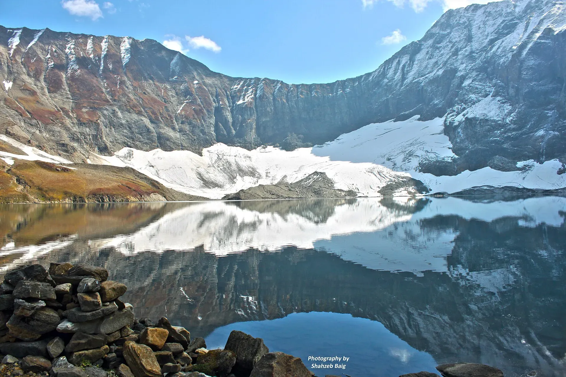
Photo: Shahzeb Baig, with thanks · CC BY-SA 4.0 · via Wikimedia Commons · temporary stand-in photo

Ratti Gali Lake Trek from Dowarian
- Duration
- 1–2 days
- Distance
- 18 km
- Grade
- Moderate
- Max altitude
- 3,683 m
- Season
- Jul – Sep
A day trip from Dowarian in the Neelum Valley to Ratti Gali Lake at 3,683 m. Wikipedia gives about 18 to 19 km, with about 16 km by 4x4 jeep and the rest on foot. Operators describe a walk of about 45 minutes to an hour from the jeep point.
Overview
Ratti Gali Lake is an alpine glacial lake at 3,683 m (Wikipedia and Dawn) in the high country above the Neelum Valley. Glacier meltwater feeds it. The usual base is Dowarian, a village about 75 km from the district headquarters at Athmuqam. One operator itinerary stays overnight at Keran, lower down the valley, and drives up to Dowarian in the morning. Most of the distance is covered by 4x4 jeep, and the final stretch is on foot.
Getting to Dowarian
From Muzaffarabad the Neelum road runs up the valley past Athmuqam and Keran to Dowarian. See the Neelum Valley road trip. From Dowarian a rough link road climbs to the lake. Dawn gives the length of this link road as 18 km. Wikipedia says 19 km in one place and 18 km in another, with about 16 km covered by jeep. Nature Adventure Club says the only way to the lake is by hiking from Dowarian, reached by 4x4.
The route
Wikipedia lists waterfalls and streams on the way. One operator describes the drive as about four hours by 4x4 from Kel. Nature Adventure Club gives a 2.5-hour drive from the Dowarian base camp followed by a one-hour walk. Another operator itinerary has jeeps leaving Dowarian at about 11 am and a walk of about 45 minutes to the lake from the jeep point. The same operator says the walk takes 2 to 3 hours in another section. Treat any time as an estimate.
Operators also describe a tent camp at the base area and camping by the lake. Wikipedia describes alpine meadows with primulas, potentillas and gentians, and lists Himalayan monal, Himalayan brown bear and Kashmir stag in the area. The wildlife entries are uncited, and the animals are rarely seen.
Beyond the lake
One operator lists Hans-Raj Lake about 4 hours on foot from the base camp, and Gattian Pass and Gattian Lake 2 to 3 hours on foot. These are operator claims and not confirmed from another source.
When to go
Wikipedia gives July to September. One operator says the road to the base camp is generally open from the first week of August to mid-October. Snow lies deep outside the main season, according to the place page, and the monsoon can damage the road. Check the state of the road in Dowarian.
Jeeps and safety
On 17 July 2024 a loader jeep carrying tourists on the link road failed on a curve and rolled back into a water channel, according to Dawn. Two tourists died, three were missing and eight were rescued. The accident happened about 3 km from the main Neelum road. Afterwards the deputy commissioner said that extended footboards and side railings had been removed from vehicles, and urged tourists to check plans with the administration or tourism police. Wikipedia says jeeps were banned pending fitness certificates and road improvements, without saying whether the ban still applies. Use a registered tourist jeep with a licensed driver, and check the current arrangements locally.
Practical information
- Carry warm clothing, food and water treatment. There are no facilities at the lake.
- Go up slowly. The lake is above 3,600 m.
- The valley is close to the Line of Control. Carry ID and follow local advice.
Highlights
- Glacial lake at 3,683 m above the Neelum Valley
- Jeep track from Dowarian, then a short walk
- Alpine meadows and waterfalls on the way
- Starting point for longer walks to other lakes, according to one operator
Day by day
- StartDowarian (jeep track from the Neelum road)
- Day 1Ratti Gali Lake
| Day | Route | Hours | Distance | Ascent / descent | Camp and altitude |
|---|---|---|---|---|---|
| Day 1 | Dowarian to Ratti Gali Lake and return | jeep to the base, then about 1 on foot (operators) | 18 km | not given | Ratti Gali Lake, 3,683 m |
Day 1 notesTake a 4x4 jeep from Dowarian up the link road, about 16 km according to Wikipedia. Leave the jeep and walk the last stretch to the lake, which operators put at about 45 minutes to an hour. Return the same way before dusk, or camp with your own tent. | |||||
Getting there
Drive from Muzaffarabad up the Neelum Valley to Dowarian, about 75 km beyond Athmuqam. Hire a 4x4 jeep in Dowarian for the link road to the base of the lake, then walk the last stretch.
Permits and rules
- Permit needed
- Check
- Fee
- Current fees will be added soon
- Last checked
- 17 November 2026
No confirmed fee or permit was found. Entry rules for the Neelum Valley have changed in the past: check with the district administration, Neelum, before travelling. Current fees will be added soon.
How trekking permits, NOCs and registration work: Visa and permits.
Season
Best: Jul – Sep
Water and camps
Guesthouses and homestays are found in the valley at Keran, Kel and Dowarian. One operator describes a tent camp at the base area. There are no facilities at the lake, so carry food and water treatment.
Gear and safety
Vehicles
Use a registered tourist jeep with a licensed driver. After the July 2024 accident, vehicles were checked and some were impounded. Ask in Dowarian about the current rules.
Altitude and weather
The lake is above 3,600 m. Weather can change fast, and the monsoon can wash out the track.
Entry rules
Neelum Valley has had temporary tourist entry bans in the past. Check with the district administration.
Ask the district administration or local police about current conditions before you go. For foreign visitors: the UK FCDO advises against all but essential travel to Azad Jammu and Kashmir, and against all travel within 10 miles of the Line of Control (advice updated 27 October 2026, checked 17 November 2026). Read the live advice before you plan.
Variations
Chitta Katha Lake and Saral Lake lie nearby. See Chitta Katha Lake Trek and Saral Lake Trek.
Tips
- Use a registered tourist jeep with a licensed driver
- Check road and entry rules with the district administration
- Start early to be back in Dowarian by afternoon
- Carry warm layers and food
- Go up slowly above 3,600 m
Photos we still need: the link road and the walk from the jeep point to the lake; Dowarian village. Send us yours
Health and emergency
Mobile signal is patchy on most treks, so tell someone your plan before you go. Emergency numbers
Sources and last checked
Last checked Confidence medium6 sources7 still to check
- Last checked
- Method
- Desk research from published sources
- Confidence
- medium
- Checked by
- trek.pk research team
Researched from published sources; not yet checked on the ground by our team. Spot something out of date? Report a mistake.
Sources
- Ratti Gali Lake · Wikipedia · checked
- Dawn report on the Ratti Gali jeep accident (17 July 2024) · Dawn · checked
- Temporary ban on tourists in Neelum Valley lifted: DC (2025) · Dawn · checked
- Ratti Gali Lake tour packages (operator itinerary, labelled as operator claims; no prices used) · Nature Adventure Club · checked
- Top lakes of Pakistan · Nature Adventure Club · checked
- Pakistan travel advice · UK FCDO · checked
Still to be checked on the ground (7)
- Whether the 2024 jeep restrictions still apply, and the current vehicle rules
- Distance: 18 or 19 km, with about 16 km by jeep (Wikipedia); the walk is 45 minutes to 3 hours depending on the operator page
- Drive time: 2.5 hours from Dowarian (Nature Adventure Club) or about 4 hours from Kel (operator)
- Lake height: 3,683 m (Wikipedia, Dawn), 3,697 or 3,698 m (Nature Adventure Club)
- Season: July to September (Wikipedia) or first week of August to mid-October (operator)
- Whether a tent camp operates at the base
- Fees for jeeps, camping or entry
Nearby and related

Other treks in Diamir

Arang Kel Trail

Chitta Katha Lake Trek (Shounter Valley)

Ratti Gali Lake
An alpine glacial lake at about 3,683 m above Dowarian in the Neelum Valley. Open in summer; the route is a rough jeep track and a walk, with strict vehicle rules since 2024.

Neelum Valley
A long, forested river valley in Azad Kashmir running north-east from Muzaffarabad to Sharda, Kel and Arang Kel. It runs close to the Line of Control, so check access before you go.

Neelum River
A 245 km river called the Kishanganga in India. About 195 km flows through Azad Kashmir's Neelum Valley before it joins the Jhelum at Muzaffarabad. Border-zone travel advice applies.

Shounter Lake
A glacial lake at about 3,100 m in the remote Shounter valley above Kel in Neelum. A rough jeep track from Kel is followed by a hike.

Sharda
A small town in the upper Neelum Valley of Azad Kashmir at about 1,981 m, known for the ruins of the Sharada Peeth temple site. It is close to the Line of Control, and official travel advice is strict.