

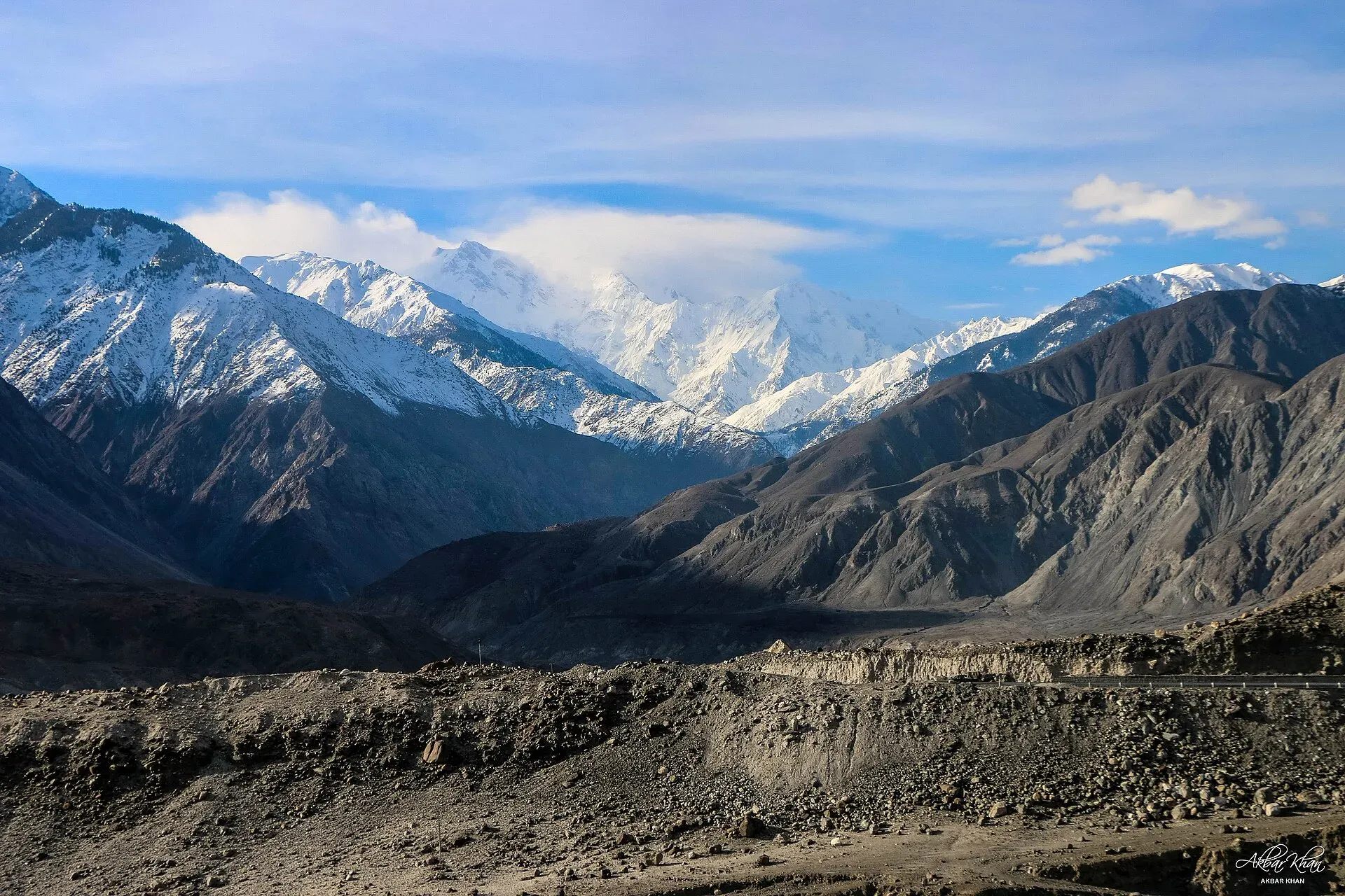
Photo: Akbar Khan Niazi, with thanks · CC BY-SA 4.0 · via Wikimedia Commons · temporary stand-in photo

Nanga Parbat View Point (Raikot)
Nanga Parbat (8,126 m) can be seen from the Karakoram Highway near Raikot Bridge, the start of the jeep track to Fairy Meadows. A roadside view; no official viewpoint is marked.
Overview
Nanga Parbat (8,126 m) can be seen from the Karakoram Highway (KKH) in the Indus valley near Raikot Bridge. No official signed viewpoint has been confirmed, so this page covers the roadside views near the bridge, where jeeps leave for Fairy Meadows.
Plan your visit
- Nearest town
- Chilas
- Getting there
Raikot Bridge is on the KKH, about 77 km from Gilgit (OSRM 54 minutes, optimistic) and about 57 km from Chilas (OSRM; tourism sheet about 50 km). Buses and vans between Gilgit and Chilas pass the bridge. More
Best months
May – Jun, Sep – Oct
- Nanga Parbat View Point (Raikot)
- Related places nearby: Nanga Parbat, Fairy Meadows, Raikot and Tatto (Fairy Meadows access), Chilas, Nanga Parbat National Park
The mountain
Nanga Parbat is the ninth-highest mountain on Earth and the westernmost major peak of the Himalayas. The name comes from Sanskrit words meaning "naked mountain", a reference to the mostly snow-free south face. Locally it is known as Diamer or Deo Mir, "mountain of God". It has three main faces: the Rupal Face to the south, the Diamir Face to the west and the Rakhiot Face to the north. The Rakhiot flank is the one visible from the highway. It rises about 7,000 m from the Indus valley to the summit in only 25 km, one of the largest rises over such a short distance anywhere.
The mountain is also called "Killer Mountain" because of the number of climbers who have died on it. Albert Mummery and Geoffrey Hastings reached about 6,100 m on the Diamir Face in 1895, and Mummery died with two Gurkha companions while exploring the Rakhiot side. Hermann Buhl made the first ascent on 3 July 1953 by the Rakhiot flank, climbing the last 1,300 m alone and without supplemental oxygen.
What to see and do
From the road you see a very large mountain wall above the river, not a close view of the glaciers. For a much closer look, take the Fairy Meadows track, described on the Fairy Meadows page.
Onward to Fairy Meadows
A jeep road of about 15 km runs from Raikot Bridge to the village of Tato (also spelled Tattu). It is narrow gravel, open only to local drivers, and is described as one of the most dangerous jeep roads in the world. From Tato, the walk to Fairy Meadows (about 3,300 m) is about 5 km, roughly 3 to 4 hours. The tourist season runs from about April to the end of September.
When to visit
Clear views are most likely in the morning and in the cooler months, when haze is less (general advice). Summer cloud and dust often hide the upper mountain. Heavy rain in July and August can cause landslides on the KKH and the Fairy Meadows track.
Where to stay and eat
There may be tea stalls near the bridge, but no confirmed list is available. Chilas and Gilgit have the nearest hotels.
Good to know
- Getting there: Raikot Bridge is about 77 km from Gilgit (OSRM, 54 minutes, optimistic; the tourism guide gives about 71 km) and about 57 km from Chilas (OSRM; the Diamer tourist sheet gives about 50 km).
- Altitude: Not confirmed for the viewpoint; the peak is 8,126 m.
- Safety: Do not stop on the bridge or the narrow carriageway. Ask the district administration or local police about current conditions before you go. For foreign visitors: the UK FCDO (updated 27 October 2026) advises against all travel on the KKH between Mansehra and Chilas, the usual road from Islamabad. It does not advise against Gilgit-Baltistan generally. Check the live page, and check local security with Gilgit-Baltistan police or tourism before going.
Highlights
- Roadside view of the 8,126 m Nanga Parbat
- Start of the jeep track to Fairy Meadows
- A rise of about 7,000 m from the Indus in 25 km
Getting there
Raikot Bridge is on the KKH, about 77 km from Gilgit (OSRM 54 minutes, optimistic) and about 57 km from Chilas (OSRM; tourism sheet about 50 km). Buses and vans between Gilgit and Chilas pass the bridge. Jeeps to Tato leave from the bridge.
Tips
- Do not stop on the bridge; pull off where the road is wide.
- Early morning gives the best chance of a clear summit.
- For a close view, continue to Fairy Meadows with a local jeep.
- Check the FCDO page and local security before travelling.
Facilities
- Tea stalls near the bridge (unconfirmed)
- Jeeps for Tato
Photos we still need: the Raikot Bridge jeep stand and the Tato track. Send us yours
Sources and last checked
Last checked Confidence medium6 sources3 still to check
- Last checked
- Method
- Desk research from published sources
- Confidence
- medium
- Checked by
- trek.pk research team
Researched from published sources; not yet checked on the ground by our team. Spot something out of date? Report a mistake.
Sources
- Nanga Parbat (Wikipedia) · Wikipedia · checked
- District Diamer tourist guide and map · Government of Pakistan tourism portal · checked
- Fairy Meadows · Wikipedia · checked
- OSRM driving route service: distances and times measured 16 November 2026 (times are optimistic, without stops) · OpenStreetMap / OSRM · checked
- Pakistan travel advice: warnings and insurance (updated 27 October 2026) · UK Foreign, Commonwealth & Development Office · checked
- Raikot Bridge (OpenStreetMap place) · OpenStreetMap contributors · checked
Still to be checked on the ground (3)
- Where on the KKH near Raikot the best roadside view is (no source)
- Viewpoint altitude (no source)
- Distance from Gilgit: 71 km (guide) vs 77 km (OSRM); the Diamer tourism sheet does not give Gilgit to Raikot, so this is unresolved
Nearby and related

Fairy Meadows and Nanga Parbat Base Camp

Nanga Parbat
Nanga Parbat (8,126 m), the ninth-highest mountain on Earth, rises above the Indus in Diamer and Astore. Fairy Meadows and the Rupal Valley give the best treks to its north and south faces.

Fairy Meadows
A grassy terrace at about 3,300 m below the north face of Nanga Parbat, reached by a rough jeep track from Raikot Bridge and then a walk of a few hours.

Raikot and Tatto (Fairy Meadows access)
Raikot Bridge on the Karakoram Highway is the start of the jeep track to Tatto, the road-end village below Fairy Meadows and the north face of Nanga Parbat.
Raikot Glacier
A 13 km glacier below the north (Raikot) face of Nanga Parbat. You see it on the walk from Tatto to Fairy Meadows and Beyal, and it leads to Nanga Parbat Base Camp.

Chilas
Headquarters of Diamer on the Karakoram Highway and the Indus, with thousands of ancient rock carvings, views towards Nanga Parbat, and the road junctions for Fairy Meadows and Babusar Pass.

Indus River
Pakistan's greatest river, rising in Tibet and running about 3,180 km to the Arabian Sea. It crosses Gilgit-Baltistan, meets the Gilgit near Jaglot and the Kabul at Attock, and feeds the plains from Tarbela to the delta.

Nanga Parbat National Park
A large high-mountain park in Diamer and Astore districts around Nanga Parbat (8,126 m), taking in Fairy Meadows, the Rupal side and Rama Lake. Notified in 2020 to 2021.

Fairy Meadows and Nanga Parbat View
A 5-day trip from Islamabad on the Karakoram Highway to Raikot Bridge, a jeep and short hike to Fairy Meadows, and the north face of Nanga Parbat (8,126 m).