

Photo: Usmanbukhari3362, with thanks · CC BY-SA 4.0 · via Wikimedia Commons · temporary stand-in photo

Fairy Meadows and Nanga Parbat View
A 5-day trip from Islamabad on the Karakoram Highway to Raikot Bridge, a jeep and short hike to Fairy Meadows, and the north face of Nanga Parbat (8,126 m).
Customise this route Change the dates, stops and how you travel in the Road Trip Planner.
Overview
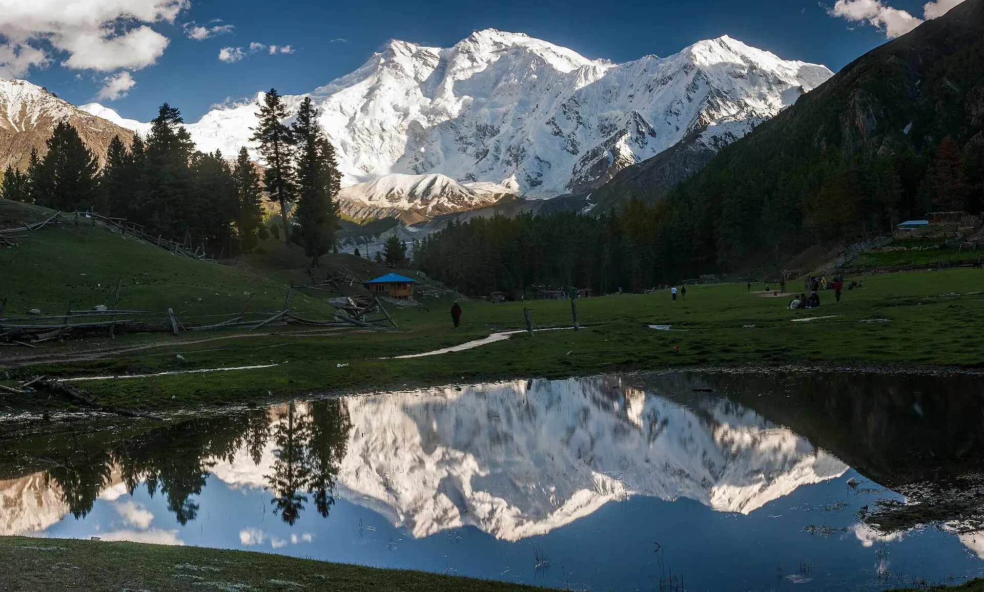
Fairy Meadows is a high pasture at about 3,300 m on the north side of Nanga Parbat, the ninth highest mountain in the world. The meadow is reached from the Karakoram Highway at Raikot Bridge by a jeep track and then a walk. This five-day plan makes the journey from Islamabad and back, with time to see the mountain properly.
Wikipedia gives the local name of the meadow as Joot; German climbers called it Märchenwiese, "fairy tale meadows". It is in Diamer District, in the Rakhiot valley at the foot of the Rakhiot glacier. It was declared a national park in 1995 and since 2021 is part of Nanga Parbat National Park. From the meadow the peak that fills the view is the North Peak (7,816 m). The true summit (8,126 m) is hidden behind it.
Who it suits
Most fit walkers, including families with older children. The walk from Tato is about 5 km and takes roughly 3 to 4 hours (Wikipedia; some operators say 2 to 3), uphill and on a steep hillside path. Wikipedia gives no jeep time for the 15 km track, and its note that the gravel road is open only to locals, who carry visitors, is the only rule on private vehicles we have found. The jeep track is narrow and has sharp drops.
When to go
Most operators run from about May to October. June to September is the reliable core; the track and meadow can be under snow before and after that. Landslides on the KKH are most common in July and August. Clouds often cover the peak by mid-morning, so the view is best at dawn.
The route in short
Islamabad to Besham and Chilas on the KKH (the road is covered in the Hunza trip). From Chilas, the Raikot Bridge is about 57 km away; from Gilgit it is about 77 km (OSRM). From Islamabad by the KKH it is about 504 km. Cross the bridge to the village on the Raikot side, take a local jeep up the track to Tato, then walk to the meadow.
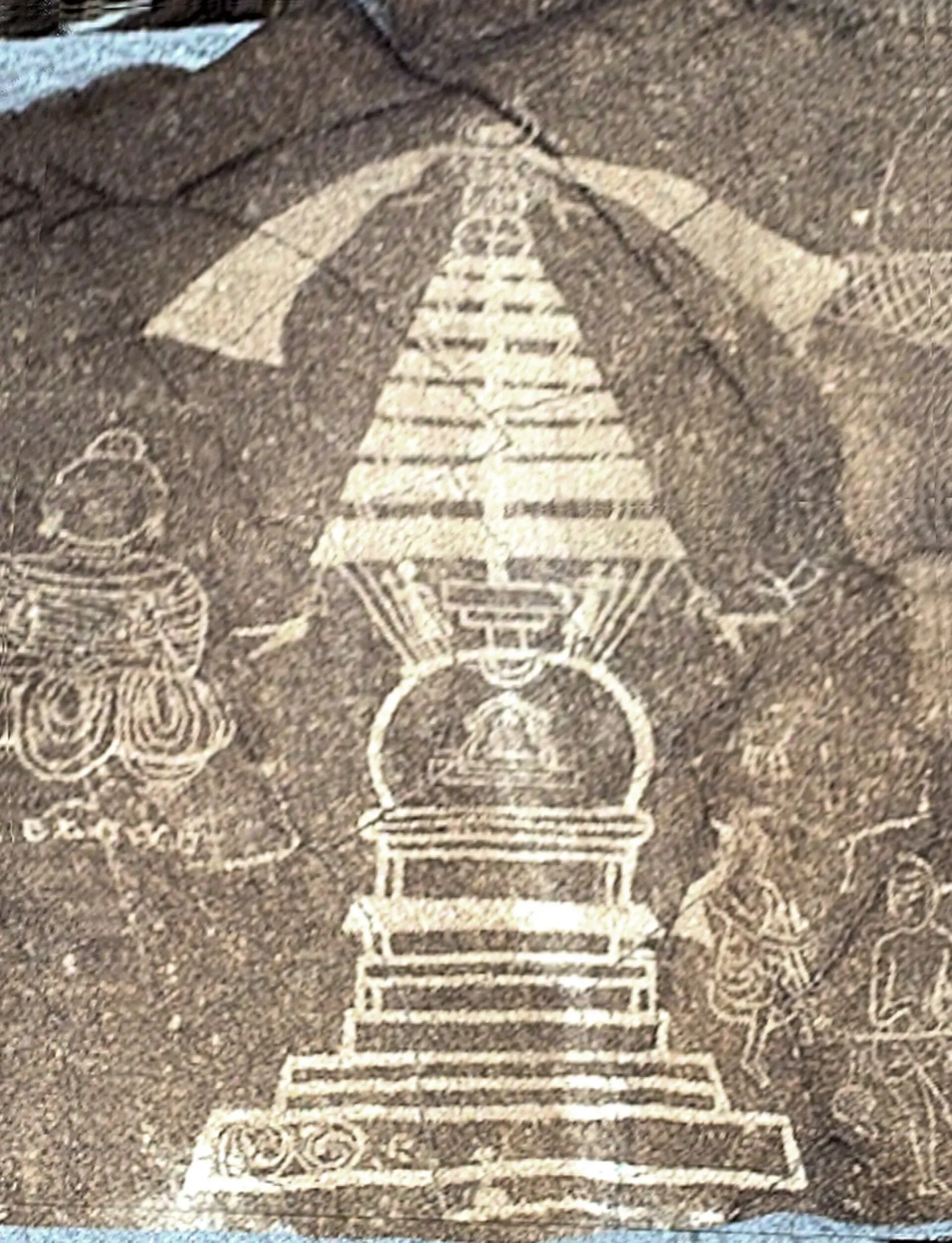
Photo: B.Degel, with thanks · Public domain (CC0) · via Wikimedia Commons · temporary stand-in photo

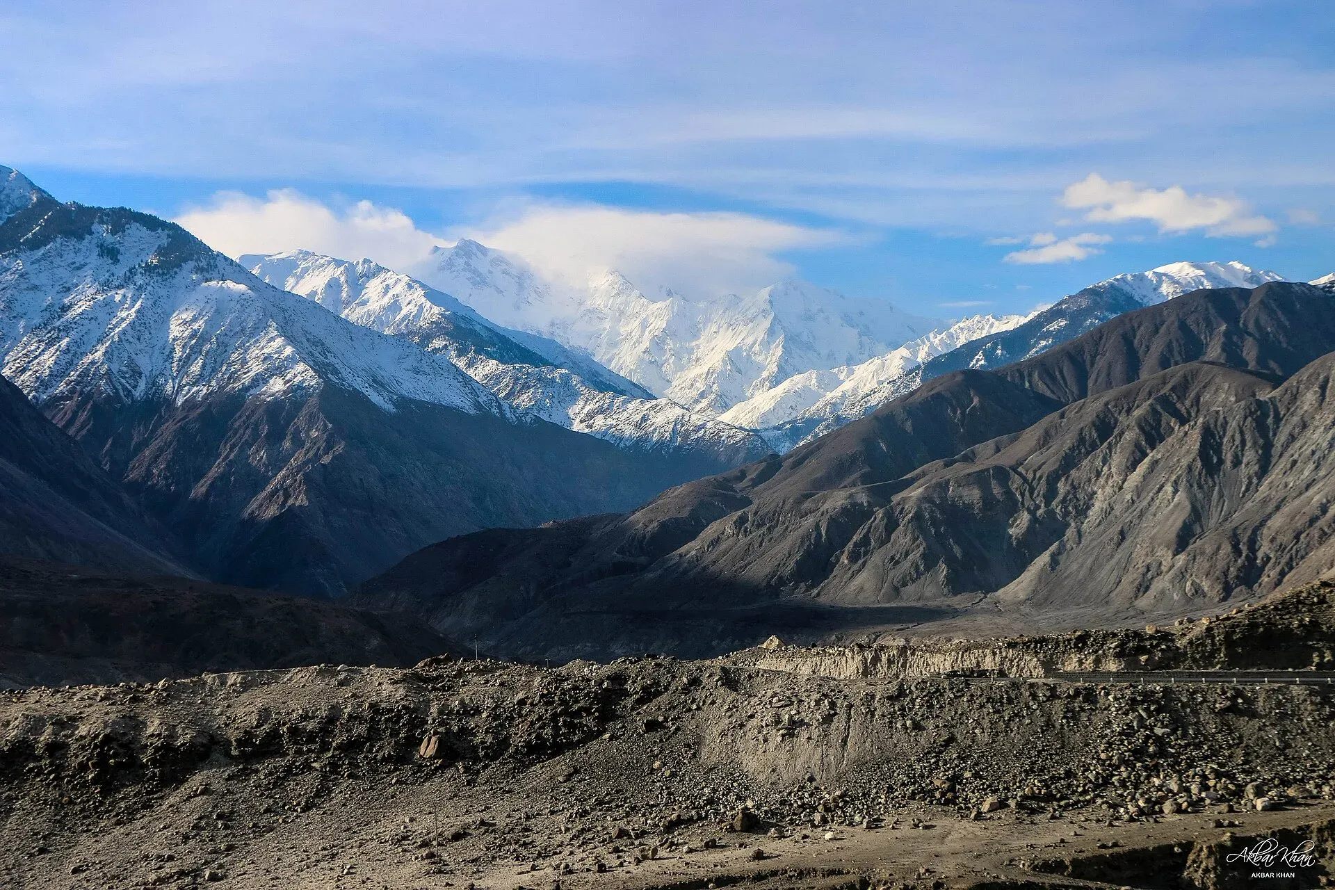
Photo: Akbar Khan Niazi, with thanks · CC BY-SA 4.0 · via Wikimedia Commons · temporary stand-in photo

Stops in order:
- Besham (about 240 km from Islamabad by the plan's OSRM figures). A usual overnight stop on the KKH.
- Chilas (about 448 km). Wikipedia describes the town as the headquarters of Diamer District, on the Indus at 1,265 m. More than 50,000 petroglyphs and inscriptions line the KKH between Hunza and Shatial, the earliest dating from roughly 5000 to 1000 BC. Examples near Chilas include a Buddhist stupa image of about 300 to 350 CE.
- Raikot Bridge (about 504 km). The jeep stand, on the KKH.
- Tato (Tattu), about 15 km up the gravel track. Wikipedia says only local drivers use this narrow road, which the WHO called the second-deadliest road in the world in 2013. Treat the ride seriously and do not pressure drivers to hurry.
- Fairy Meadows, a 5 km walk of three to four hours from Tato.
At Fairy Meadows
Beyond the meadow, a path leads to a viewpoint, often called Beyal Camp, at around 3,600 m. You can go further on a longer trek to the base camp. The village has simple wooden huts and campsites. Locals have run the camping sites since 1992 and stopped cutting timber in the forest to protect it (Wikipedia). The meadow is a protected pasture, so camp only in the marked areas and take your rubbish down.
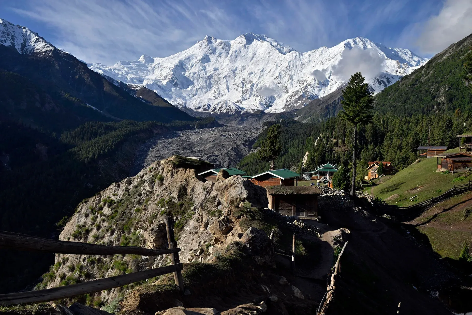
Photo: Moskenes, with thanks · CC BY-SA 4.0 · via Wikimedia Commons · temporary stand-in photo

The forest above the meadow is alpine: pine, spruce and fir on higher north-facing slopes, birch and willow in shaded high ground and juniper on southern slopes. Wikipedia mentions a few brown bears and some musk deer, both declining. Wikipedia gives the season as April to September, while operators usually quote about May to October, so check conditions before an October trip.
Treks and side trips
The natural next step is the Fairy Meadows and Nanga Parbat Base Camp trek. On the other side of the mountain, the Rupal and Mazeno La routes start from Astore. From Gilgit you can add Rakaposhi viewpoint, Naltar or Hunza.
Distances
Distances and times in this plan are from OSRM / OpenStreetMap, measured on 16 November 2026. They are driving time only, without stops, and OSRM is optimistic on mountain roads, unpaved tracks and in traffic, so real journeys are usually clearly longer; treat the times as a minimum.
Respect for local people
The jeep and porter work is shared among local communities, who have their own rules. Follow them, agree arrangements clearly and do not argue about local rules on the road.
Highlights
- Nanga Parbat from the meadow at dawn
- The jeep track from Raikot Bridge
- Beyal Camp viewpoint
- Pine forest walks
- Raikot Glacier
Stops
- BeshamOvernight option
- ChilasOvernight option
- Raikot BridgeJeep stand for Tato
- TatoEnd of the jeep track (about 15 km from the bridge, Wikipedia)
- Fairy MeadowsAbout 5 km on foot from Tato (Wikipedia: 3 to 4 hours)
km: distance from the start along the route.
Numbers follow the stops in order. The map shows the 4 stops that have a trek.pk page, not the road itself.
Day by day
Day 1 · Islamabad to Chilas
A long day on the KKH. If you want a shorter day, stop at Besham (240 km, 3 h 02 by OSRM) and reach Raikot Bridge on Day 2.
Day 2 · Chilas to Raikot Bridge and Tato, then walk to Fairy Meadows
Drive 57 km to Raikot Bridge, take a jeep for about 15 km to Tato (Wikipedia), then climb about 5 km to the meadow, which Wikipedia puts at 3 to 4 hours on foot. Arrive before dark.
Day 3 · Fairy Meadows and Beyal viewpoint
Walk up to the viewpoint at dawn for the best light. Rest in the afternoon, or walk in the forest.
Day 4 · Down to Tato and on to Gilgit or Chilas
Walk down in the morning, take the jeep to the bridge, then continue by road. Gilgit is 77 km from the bridge by OSRM.
Day 5 · Gilgit to Islamabad
Allow two days if you are driving (Gilgit to Islamabad by the KKH is about 585 km). Do not drive Besham to Chilas after dark.
Road conditions
- KKH to Raikot Bridge: paved, but the Besham to Chilas section is slow and slide-prone. One trip report describes the stretch from Chilas to Raikot Bridge as rough.
- Raikot Bridge to Tato: an unpaved, narrow track of about 15 km (Wikipedia), used by local jeeps. Not for private cars.
- Tato to Fairy Meadows: footpath only.
- Season: snow closes the upper path in winter. Landslides can close the KKH for hours or days at any time.
Distances and times in this plan are from OSRM / OpenStreetMap, measured on 16 November 2026. They are driving time only, without stops, and OSRM is optimistic on mountain roads, unpaved tracks and in traffic, so real journeys are usually clearly longer; treat the times as a minimum.
Fuel and services
Fuel at Besham, Chilas and Gilgit; none above Raikot. Fairy Meadows has simple huts, camping and basic food, with no ATM and limited phone signal. Carry cash, a headtorch, and any medicine you need.
Where to stay, eat and fuel up
Places to stay
- Shangrila Chilas HotelCall Shangrila Chilas HotelMap of Shangrila Chilas Hotel in Google Maps
- Eagle's Nest Hotel HunzaCall Eagle's Nest Hotel HunzaMap of Eagle's Nest Hotel Hunza in Google Maps
- Indus Lodges GilgitCall Indus Lodges GilgitMap of Indus Lodges Gilgit in Google Maps
- Gilgit Serena HotelCall Gilgit Serena HotelMap of Gilgit Serena Hotel in Google Maps
- Park Hotel GilgitCall Park Hotel GilgitMap of Park Hotel Gilgit in Google Maps
- Hotel SarbanCall Hotel SarbanMap of Hotel Sarban in Google Maps
Places to eat
- KFC | AbbottabadCall KFC | AbbottabadMap of KFC | Abbottabad in Google Maps
- Yum Bakery and CafeCall Yum Bakery and CafeMap of Yum Bakery and Cafe in Google Maps
- Food PlanetCall Food PlanetMap of Food Planet in Google Maps
- Flame On Jadoon PlazaCall Flame On Jadoon PlazaMap of Flame On Jadoon Plaza in Google Maps
- BaithakCall BaithakMap of Baithak in Google Maps
- Food HutCall Food HutMap of Food Hut in Google Maps
Essential services fuel stations, ATMs, banks, pharmacies and hospitals and clinics
Fuel
- ShellCall ShellMap of Shell in Google Maps
- Attock Petrol PumpMap of Attock Petrol Pump in Google Maps
- PSO ROYAL STAR FILLING STATIONCall PSO ROYAL STAR FILLING STATIONMap of PSO ROYAL STAR FILLING STATION in Google Maps
- Ibex PSO Petrol StationMap of Ibex PSO Petrol Station in Google Maps
- PSO SostCall PSO SostMap of PSO Sost in Google Maps
- Sakhi Darbar PSO Petrol PumpMap of Sakhi Darbar PSO Petrol Pump in Google Maps
ATMs
- World's Highest ATM NBPMap of World's Highest ATM NBP in Google Maps
- National Bank of Pakistan (NBP) Mirpur/Mandian BranchCall National Bank of Pakistan (NBP) Mirpur/Mandian BranchMap of National Bank of Pakistan (NBP) Mirpur/Mandian Branch in Google Maps
- HBLMap of HBL in Google Maps
- Allied Bank LimitedCall Allied Bank LimitedMap of Allied Bank Limited in Google Maps
- United Bank LimitedMap of United Bank Limited in Google Maps
- The Bank of PunjabCall The Bank of PunjabMap of The Bank of Punjab in Google Maps
Banks and money exchange
- National Bank of Pakistan (NBP)Call National Bank of Pakistan (NBP)Map of National Bank of Pakistan (NBP) in Google Maps
- Telenor Microfinance BankMap of Telenor Microfinance Bank in Google Maps
- Allied Bank LtdCall Allied Bank LtdMap of Allied Bank Ltd in Google Maps
Pharmacies
- Alam Family HospitalCall Alam Family HospitalMap of Alam Family Hospital in Google Maps
- Bilal PlazaCall Bilal PlazaMap of Bilal Plaza in Google Maps
- Qureshi Brothers Chemists and DruggistCall Qureshi Brothers Chemists and DruggistMap of Qureshi Brothers Chemists and Druggist in Google Maps
Hospitals and clinics
- Shamshad Aslam HospitalCall Shamshad Aslam HospitalMap of Shamshad Aslam Hospital in Google Maps
- Fatima HospitalCall Fatima HospitalMap of Fatima Hospital in Google Maps
- Umer Hospital Wah CanttCall Umer Hospital Wah CanttMap of Umer Hospital Wah Cantt in Google Maps
- Aga Khan Hospital, GilgitCall Aga Khan Hospital, GilgitMap of Aga Khan Hospital, Gilgit in Google Maps
- Shifa Physiotherapy ClinicCall Shifa Physiotherapy ClinicMap of Shifa Physiotherapy Clinic in Google Maps
- City HospitalCall City HospitalMap of City Hospital in Google Maps
Listings come from Google Maps data and are unverified: phone numbers, opening months and prices may have changed. Report a problem · Own one of these? Claim it
Safety
- Jeep track: steep drops. Wear your seatbelt if there is one and tell the driver if you are nervous.
- Weather: afternoon cloud, rain and cold; the path can be slippery.
- Landslides on the KKH: the main risk, most of all in July and August. NDMA issued a landslide alert for GB in January 2026 naming the KKH, and Dawn reported travellers stranded in 2026.
- Altitude: the meadow is above 3,000 m; go slowly and drink water.
- Security: an attack on climbers at Nanga Parbat base camp in 2013 led to stricter checks in this area. Registration and police checks are routine; carry identity documents and follow local advice.
Ask the district administration or local police about current conditions before you go. For foreign visitors: the UK FCDO advises against all travel on the Karakoram Highway between Mansehra and Chilas (advice updated 27 October 2026, checked 16 November 2026), but does not advise against Gilgit-Baltistan generally. Read the live advice before you plan.
Tips
- Start the walk early; the hillside is hot and dry in the morning sun.
- Carry a warm layer and a rain jacket; nights are cold even in July.
- Book your hut or camp in advance in July and August.
- Only local jeeps are normally allowed on the Raikot to Tato track.
- Leave Islamabad by 6 am; the KKH delays are long in summer.
Photos we still need: the Raikot Bridge and the jeep track to Tato. Send us yours
Sources and last checked
Last checked Confidence medium8 sources4 still to check
- Last checked
- Method
- Desk research from published sources
- Confidence
- medium
- Checked by
- trek.pk research team
Researched from published sources; not yet checked on the ground by our team. Spot something out of date? Report a mistake.
Sources
- Pakistan Tourism Guide 2021 · Trade Development Authority of Pakistan (TDAP) · checked
- Fairy Meadows · Wikipedia · checked
- Nanga Parbat · Wikipedia · checked
- NDMA issues landslide alerts for KP, Balochistan, GB, AJK (January 2026) · Radio Pakistan · checked
- Travellers stranded as landslides block Karakoram Highway · Dawn · checked
- OSRM driving route service: distances and times measured 16 November 2026 (drive times are without stops) · OSRM / OpenStreetMap contributors · checked
- Fairy Meadows · Wikipedia · checked
- Chilas · Wikipedia · checked
Still to be checked on the ground (4)
- Jeep time (1-2 hours) and walking time (2-4 hours) vary by source; Wikipedia gives 3 to 4 hours on foot and no jeep time
- Current rules for private vehicles on the Raikot to Tato track (Wikipedia says the road is open only to locals who provide transport; no official notice found)
- Whether huts and campsites are open in October (Wikipedia gives the season as April to end of September; no 2026 source)
- OSRM does not map the jeep track reliably, so the 15 km jeep and 5 km walk come from Wikipedia (re-checked 16 November 2026: 15 km jeep, 5 km walk)
Nearby and related

Fairy Meadows and Nanga Parbat Base Camp

Rupal Valley and Nanga Parbat Rupal Face
Mazeno La

Rakaposhi Base Camp

Fairy Meadows
A grassy terrace at about 3,300 m below the north face of Nanga Parbat, reached by a rough jeep track from Raikot Bridge and then a walk of a few hours.

Nanga Parbat
Nanga Parbat (8,126 m), the ninth-highest mountain on Earth, rises above the Indus in Diamer and Astore. Fairy Meadows and the Rupal Valley give the best treks to its north and south faces.

Nanga Parbat View Point (Raikot)
Nanga Parbat (8,126 m) can be seen from the Karakoram Highway near Raikot Bridge, the start of the jeep track to Fairy Meadows. A roadside view; no official viewpoint is marked.
Raikot Glacier
A 13 km glacier below the north (Raikot) face of Nanga Parbat. You see it on the walk from Tatto to Fairy Meadows and Beyal, and it leads to Nanga Parbat Base Camp.

Beyal Camp Viewpoint
Beyal is a quiet high meadow camp beyond Fairy Meadows at about 3,500 m, with the 'View Point' boulder (3,667 m) 30 minutes further, looking at the icefalls of Nanga Parbat's north face.

Chilas
Headquarters of Diamer on the Karakoram Highway and the Indus, with thousands of ancient rock carvings, views towards Nanga Parbat, and the road junctions for Fairy Meadows and Babusar Pass.

Gilgit
Gateway to Gilgit-Baltistan on the Karakoram Highway: a busy mountain town with the Kargah Buddha and the base for Hunza, Naltar and Skardu.

Besham
A busy Indus-side town and junction on the Karakoram Highway at about 613 m, long used as the first overnight stop from Islamabad towards Gilgit and Hunza.

Rakaposhi View Point
A roadside stop on the Karakoram Highway at Ghulmet in Nagar, about 60 km from Gilgit, with a close view of Rakaposhi (7,788 m) rising above the Hunza River.

Hunza and Khunjerab (KKH)
A 7-8 day road trip from Islamabad up the Karakoram Highway to Hunza and on to Khunjerab Pass (4,693 m), with overnight stops at Besham, Chilas and Gilgit.

Naran, Kaghan and Babusar
A 4-day summer road trip from Islamabad up the Kaghan valley to Naran, Saiful Muluk and Lulusar Lake, over Babusar Pass (4,173 m) to Chilas on the KKH.

N-35 Karakoram Highway: Hasan Abdal-Khunjerab
The Karakoram Highway runs from Hasan Abdal through Hazara, Kohistan, Gilgit and Hunza to Khunjerab Pass (4,714 m) and China. Landslides are frequent and the UK advises against travel between Mansehra and Chilas.