

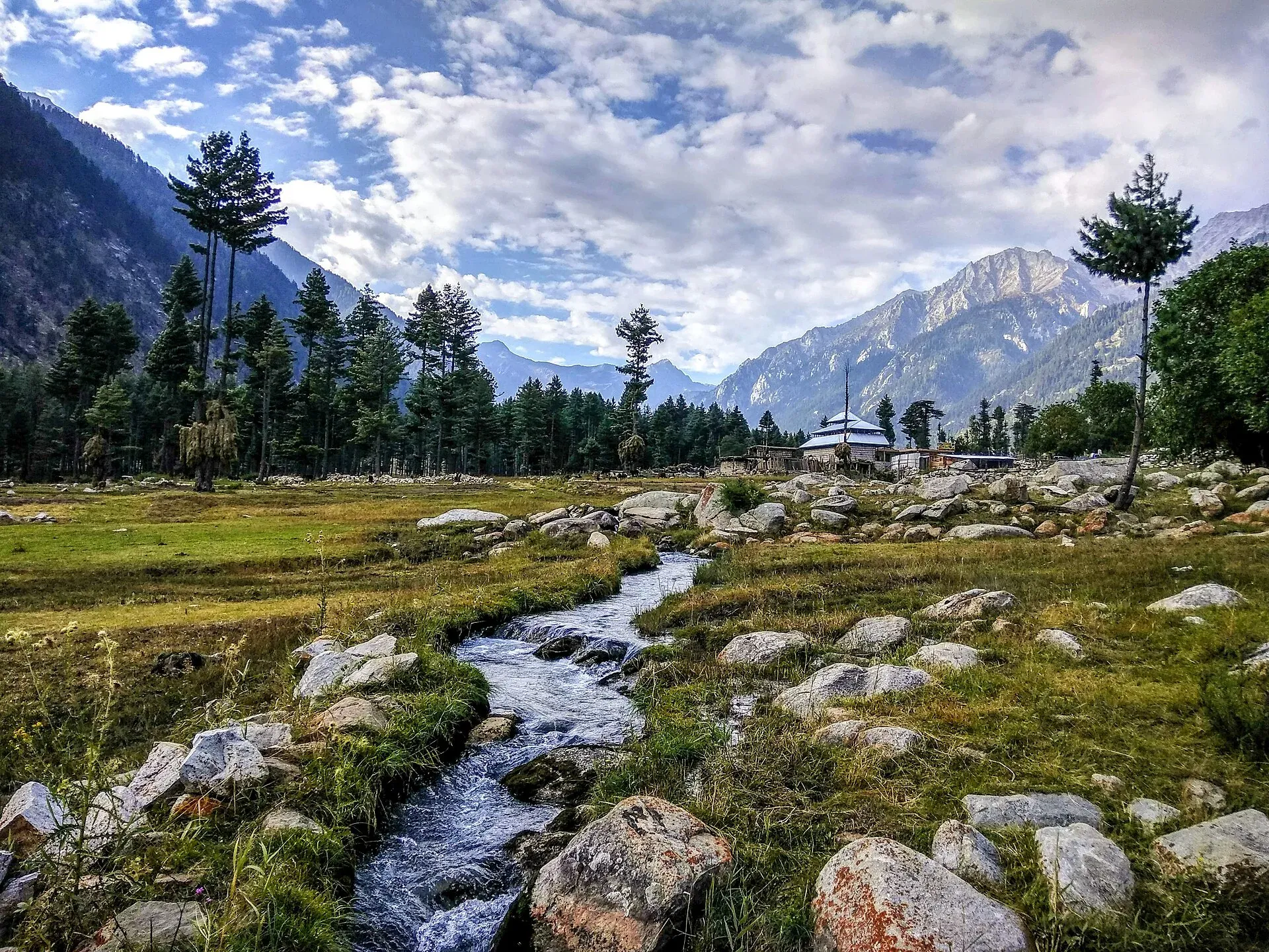
Photo: Ali Rasheed, with thanks · CC BY-SA 4.0 · via Wikimedia Commons · temporary stand-in photo

Kumrat Valley
A 4-day road trip from Islamabad to Kumrat in Upper Dir: deodar forest, the Panjkora river and waterfalls, via Chakdara, Dir and Thal, with a final jeep leg.
Customise this route Change the dates, stops and how you travel in the Road Trip Planner.
Overview
Kumrat is a forested valley in Upper Dir, in Khyber Pakhtunkhwa, with deodar forests, the Panjkora river, waterfalls and meadows. It is much quieter than Swat and Naran but has become popular with weekenders and campers. The trip is four days from Islamabad: one long drive in, a day or two in the valley and a day out.
Who it suits
Campers, photographers and anyone happy with basic facilities. The final leg from Thal is a rough track that needs a 4x4. It is not a trip for low cars.
When to go
May to September is the main season. Sources vary: some advise avoiding November to March because of snow, others suggest avoiding July and August because of the monsoon. Roads here have been damaged by floods; one report says the road was restored after three days of heavy rain in 2025. Eid holidays are very busy.
The route in short
Islamabad to Chakdara by the M-1 and Swat Motorway, then Timergara and Dir. From Dir the road runs up the Panjkora valley through Sheringal to Thal, the usual base. Beyond Thal the road is rough and best done by local jeep, taking roughly 45-60 minutes by agency pages. Other accounts range from about 40 minutes (to Takki Top) to two or three hours, depending on where in the valley you stop and the state of the track; a 2021 blog (Lost With Purpose) says "an hour or two" and calls the ride bumpy. Agency pages give about 370-400 km and 9 hours from Islamabad. OSRM measures 375 km to Thal and 383 km to the Kumrat valley, about 4 h 56 of driving without stops; the OSRM time is a minimum and the road beyond Dir is slow, so the agency figure is closer to real life.
Stages from Islamabad
- Islamabad to Chakdara (km 193, OSRM estimate): the M-1 to the Mardan interchange, then the Swat Motorway. Wikivoyage says the Swat Motorway avoids the traffic near Malakand Pass and saves about an hour, but its page may predate the full opening. Chakdara has a fort above the Swat River.
- Chakdara to Timergara (km 233) and Dir (km 304): Lower Dir and Upper Dir districts, with fuel and hotels. Dir is the usual overnight stop for anyone who starts late.
- Dir to Sheringal (km 333) and Thal (km 375): the Panjkora valley road. It is paved but narrow in places, and slower than OSRM suggests.
- Thal to Kumrat (km 383): the jeep track.
From Kalam over the pass
A 2021 blog (Lost With Purpose) describes a second way in from Swat: a shared taxi from Kalam bazaar to Utror, about an hour, then a shared jeep over a pass above 3,000 m to Thal, roughly four hours. It calls Thal the launch point for Kumrat, about 45 km away, and suggests staying a night to arrange the jeep and supplies. Shared jeeps leave when full, so timing is unpredictable. The route is described from one traveller's trip, so check the road with locals first.
What to see
- Kumrat deodar forests, with riverside camping.
- Kumrat waterfall a short walk from the camp area.
- Jahaz Banda, a high meadow reached by a long jeep or hike beyond Kumrat; tour operators run it as a jeep ride to Takki Top and then a hike of about 2 to 4 hours (estimates differ), and there is no known source giving a firm opening season, so check with local guides about the route and snow.
On the track and in the valley
The same blog describes a bumpy ride of one to two hours from Thal, narrow in places, with an army checkpoint on the way. Agree the drop-off and pick-up points with the driver before you set off. In season there are many tent camps, offering similar facilities; some close out of season. Food is basic and limited, so most visitors bring their own. The blog's author was told that overnight stays were limited to an army guest house or required a local companion, but was also told other visitors could sleep in the valley, so ask on arrival rather than assuming either.
Local life and respect
The valley is Kohistani and Pashtun, with small communities and few services. Ask before camping near homes, follow local rules and take rubbish away. A fee may apply for camping or entry; there is no known official tariff from the Upper Dir administration or the KP tourism authority, and tour operators only list tickets as extras, so current fees will be added soon.
Distances
Distances and times in this plan are from OSRM / OpenStreetMap, measured on 16 November 2026. They are driving time only, without stops, and OSRM is optimistic on mountain roads, unpaved tracks and in traffic, so real journeys are usually clearly longer; treat the times as a minimum.
Treks and side trips
Ask local guides about walks towards Jahaz Banda. Swat and Chitral are nearby, and the Swat and Kalam and Chitral and Kalash trips can be combined with this one.
Highlights
- Deodar forest camping
- Panjkora river
- Kumrat waterfall
- Jahaz Banda meadow
- Quiet alternative to Swat
Stops
- ChakdaraJunction towards Dir; fort above the Swat River
- TimergaraLower Dir
- DirFuel and overnight option
- SheringalRoad gets rougher after here
- ThalBase; 4x4 hire
- KumratJeep only; camping and waterfall
km: distance from the start along the route.
Numbers follow the stops in order. The map shows the 4 stops that have a trek.pk page, not the road itself.
Day by day
Day 1 · Islamabad to Dir or Thal
Take the motorways to Chakdara and the Dir road. Dir is 304 km from Islamabad and Thal 375 km. Stay in Dir or push to Thal if you start early.
Day 2 · Thal to Kumrat by jeep
Take the jeep from Thal (9 km to the Kumrat valley point used here; the camp areas and waterfall are a few kilometres further, about 13 km to the waterfall). Set up camp, walk in the forest and visit the waterfall.
Day 3 · Kumrat: Jahaz Banda or rest
Take a guided jeep or walk to Jahaz Banda, or rest.
Day 4 · Kumrat to Islamabad
A long day (383 km). Start early and aim to leave Dir before 1 pm.
Road conditions
- Islamabad to Dir: paved via motorway and N-45, with congestion near Chakdara and Timergara.
- Dir to Sheringal and Thal: paved but narrow in places. One traveller described the road after Sheringal as among the worst they had driven.
- Thal to Kumrat: track needing a 4x4. Floods can wash away sections; a 2025 report describes repairs after heavy rain.
Distances and times in this plan are from OSRM / OpenStreetMap, measured on 16 November 2026. They are driving time only, without stops, and OSRM is optimistic on mountain roads, unpaved tracks and in traffic, so real journeys are usually clearly longer; treat the times as a minimum.
Fuel and services
Fuel at Chakdara, Timergara, Dir and sometimes Thal; carry spare fuel for the jeep track. Hotels at Dir. In Kumrat expect basic guesthouses, camping and small shops. Cash only. Phone coverage is limited above Thal.
Where to stay, eat and fuel up
Places to stay
- Serena HotelCall Serena HotelMap of Serena Hotel in Google Maps
- Islamabad Marriott HotelCall Islamabad Marriott HotelMap of Islamabad Marriott Hotel in Google Maps
- Mabali IslandCall Mabali IslandMap of Mabali Island in Google Maps
- Ramada by Wyndham IslamabadCall Ramada by Wyndham IslamabadMap of Ramada by Wyndham Islamabad in Google Maps
- Avari Xpress Residences Islamabad HotelCall Avari Xpress Residences Islamabad HotelMap of Avari Xpress Residences Islamabad Hotel in Google Maps
- Movenpick Hotel CentaurusCall Movenpick Hotel CentaurusMap of Movenpick Hotel Centaurus in Google Maps
Places to eat
- The Monal IslamabadCall The Monal IslamabadMap of The Monal Islamabad in Google Maps
- Tehzeeb Bakers Blue AreaCall Tehzeeb Bakers Blue AreaMap of Tehzeeb Bakers Blue Area in Google Maps
- TKR 3Call TKR 3Map of TKR 3 in Google Maps
- Savour FoodsCall Savour FoodsMap of Savour Foods in Google Maps
- Cheezious Commercial MarketCall Cheezious Commercial MarketMap of Cheezious Commercial Market in Google Maps
- Savour FoodsCall Savour FoodsMap of Savour Foods in Google Maps
Essential services fuel stations, mechanics, pharmacies and hospitals and clinics
Fuel
- Attock Petrol PumpMap of Attock Petrol Pump in Google Maps
- PSO Petrol PumpMap of PSO Petrol Pump in Google Maps
- PSO Petrol Pump (Zoom Filling)Call PSO Petrol Pump (Zoom Filling)Map of PSO Petrol Pump (Zoom Filling) in Google Maps
- Attock Petrol PumpCall Attock Petrol PumpMap of Attock Petrol Pump in Google Maps
- Byco Petrol Pump (Range Road)Map of Byco Petrol Pump (Range Road) in Google Maps
- PSO Petrol PumpCall PSO Petrol PumpMap of PSO Petrol Pump in Google Maps
Mechanics and tyre shops
- Mohammed Bilal tyre centreMap of Mohammed Bilal tyre centre in Google Maps
- Toyota GT MotorsCall Toyota GT MotorsMap of Toyota GT Motors in Google Maps
- JAPAN TYRES Blue AreaCall JAPAN TYRES Blue AreaMap of JAPAN TYRES Blue Area in Google Maps
- Polygon CastCall Polygon CastMap of Polygon Cast in Google Maps
- Hybrid SpecialistCall Hybrid SpecialistMap of Hybrid Specialist in Google Maps
- Honda CapitalCall Honda CapitalMap of Honda Capital in Google Maps
Pharmacies
- Imtiaz Mega - Ramzan Mall - islamabadCall Imtiaz Mega - Ramzan Mall - islamabadMap of Imtiaz Mega - Ramzan Mall - islamabad in Google Maps
- D.WATSON CHEMIST BLUE AREACall D.WATSON CHEMIST BLUE AREAMap of D.WATSON CHEMIST BLUE AREA in Google Maps
- D.WATSON CHEMIST F-11 MARKAZCall D.WATSON CHEMIST F-11 MARKAZMap of D.WATSON CHEMIST F-11 MARKAZ in Google Maps
- Shaheen Chemist I-8 MarkazCall Shaheen Chemist I-8 MarkazMap of Shaheen Chemist I-8 Markaz in Google Maps
- Shaheen ChemistCall Shaheen ChemistMap of Shaheen Chemist in Google Maps
- D. Watson Chemist F-10 MarkazCall D. Watson Chemist F-10 MarkazMap of D. Watson Chemist F-10 Markaz in Google Maps
Hospitals and clinics
- Shifa International Hospitals LimitedCall Shifa International Hospitals LimitedMap of Shifa International Hospitals Limited in Google Maps
- Amanat Eye Hospital RawalpindiCall Amanat Eye Hospital RawalpindiMap of Amanat Eye Hospital Rawalpindi in Google Maps
- Maryam Memorial Hospital (MMH)Call Maryam Memorial Hospital (MMH)Map of Maryam Memorial Hospital (MMH) in Google Maps
- Combined Military Hospital Rawalpindi (CMH)Call Combined Military Hospital Rawalpindi (CMH)Map of Combined Military Hospital Rawalpindi (CMH) in Google Maps
- Advanced International Hospital IslamabadCall Advanced International Hospital IslamabadMap of Advanced International Hospital Islamabad in Google Maps
- Brain Surgery HospitalCall Brain Surgery HospitalMap of Brain Surgery Hospital in Google Maps
Listings come from Google Maps data and are unverified: phone numbers, opening months and prices may have changed. Report a problem · Own one of these? Claim it
Safety
- Floods and landslides: the river can rise quickly. Avoid camping at the river edge.
- Rough track: do not take a low car beyond Thal.
- Local conditions: check with district police or administration about security notices before you go. There is no known Kumrat-specific advisory as of 16 November 2026.
- Winter: snow can close the road from late autumn.
Ask the district administration or local police about current conditions before you go. For foreign visitors: the UK FCDO advises against all travel to Upper Dir and Lower Dir, and on the N-45 north of the Mardan ring road (advice updated 27 October 2026, checked 16 November 2026). Read the live advice before you plan.
Tips
- Use a local 4x4 for the Thal to Kumrat track.
- Bring a tent, sleeping bag and food; supplies are thin.
- Check flood news before leaving, especially in July and August.
- Start from Dir early; the road is slow after Sheringal.
- Camp away from the riverbank in the rains.
Sources and last checked
Last checked Confidence low7 sources6 still to check
- Last checked
- Method
- Desk research from published sources
- Confidence
- low
- Checked by
- trek.pk research team
Researched from published sources; not yet checked on the ground by our team. Spot something out of date? Report a mistake.
Sources
- Pakistan Tourism Guide 2021 · Trade Development Authority of Pakistan (TDAP) · checked
- Kumrat Valley Distance from Islamabad - Travel Guide 2025 · The Truth International · checked
- Kumrat valley road restored for Eid tourism after heavy rain and flooding · TNN English · checked
- NDMA issues landslide alerts for KP, Balochistan, GB, AJK (January 2026) · Radio Pakistan · checked
- OSRM driving route service: distances and times measured 16 November 2026 (drive times are without stops) · OSRM / OpenStreetMap contributors · checked
- Guide to Kumrat Valley in Khyber Pakhtunkhwa (updated 15 July 2021) · Lost With Purpose · checked
- Swat Valley (Wikivoyage) · Wikivoyage · checked
Still to be checked on the ground (6)
- Thal to Kumrat jeep time and road state today (sources range from 40 minutes to 3 hours)
- Official camping or entry fees and who collects them (none found from an official source)
- Jahaz Banda access and season (no firm season in any source opened)
- Thal to Kumrat distance: OSRM gives 9 km to the valley point and 13 km to the waterfall; one 2021 blog says Thal is about 45 km from Kumrat, so sources vary
- Whether overnight stays in Kumrat are restricted for foreign visitors or groups (a 2021 blog reports being told of limits; no official notice found)
- Kalam to Thal shared-jeep route: one 2021 blog only; time and road state not confirmed
Nearby and related

Kumrat Valley
The upper Panjkora valley in Upper Dir, known for deodar forest, the Jahaz Banda meadow and Katora Lake. Access has been cut by floods and a collapsed bridge in 2025 and 2026.

Kumrat Waterfall
A waterfall in Kumrat Valley, Upper Dir, in the Panjkora river area. Sources are thin and sometimes confusing. For foreign visitors: the UK FCDO advises against all travel to Upper Dir.
Kumrat Valley Campsites
Riverside campsites among the deodar forest of Kumrat in Upper Dir. For foreign visitors: the UK FCDO advises against all travel to Upper Dir, and floods have cut access in 2025 and 2026.
Kumrat Deodar Forests
The dense deodar forests of Kumrat in the upper Panjkora valley, Upper Dir. Access was cut by floods and a collapsed bridge in 2025 and 2026, and the FCDO advises against travel to Upper Dir.

Jahaz Banda
A large high meadow at about 3,100 m in the upper Kumrat Valley, Upper Dir, reached by a rough jeep road and a walk. UK travel advice is against all travel to Upper Dir.

Dir
The old capital of the princely state of Dir, on the Dir River at the foot of the Lowari Pass, with a palace on the hill above. A stop on the road between Peshawar and Chitral.

Timergara
District capital of Lower Dir on the Panjkora River, at about 823 m. For foreign visitors: the UK FCDO advises against all travel to Lower Dir, so this is for information only.

Swat and Kalam
A 4-5 day road trip from Islamabad up the Swat valley by the M-16 and N-95 to Mingora, Madyan, Bahrain and Kalam, with Mahodand Lake and Ushu forest in summer.

Chitral and Kalash
A 6-7 day road trip from Islamabad to Chitral through Dir and the Lowari Tunnel, with the Kalash valleys of Bumburet, Rumbur and Birir, Chitral Fort and Tirich Mir views.

N-45 Nowshera-Chitral
The 309 km N-45 runs from Nowshera over the Malakand pass area through Lower and Upper Dir, then through the 10.4 km Lowari Tunnel to Chitral. The UK advises against travel on it from north of Mardan to Chitral.