

Photo: Ijlalahmed, with thanks · CC BY-SA 4.0 · via Wikimedia Commons · temporary stand-in photo

Islamabad Capital Territory
Pakistan's planned capital at the foot of the Margalla Hills: Faisal Mosque, Daman-e-Koh, hiking trails, museums and the gateway to the north.
Overview
Islamabad is Pakistan's capital, built from the 1960s as a planned city on the Potohar Plateau. The Islamabad Capital Territory covers about 906 square kilometres and had 2.36 million people at the 2023 census (2,363,863). The Margalla Hills rise to the north as a green backdrop. Most visitors to the northern mountains pass through here, and Rawalpindi, the older city, lies immediately to the south. Together the two are known as the Twin Cities.
The site was chosen in 1959, the name was approved on 24 February 1960, construction began in 1961 and the city was inaugurated on 14 August 1967. One reason for the choice was that Karachi, the earlier capital, sat at the southern edge of the country; the new site was close to army headquarters in Rawalpindi.
Plan your visit
- Getting there
By air. Islamabad International Airport (opened in 2018) is roughly 20 to 25 km from the centre and is the main entry point for the north. More
Best months
Feb – Apr, Sep – Nov
- Islamabad Capital Territory
- Related places nearby: Islamabad, Margalla Hills National Park, Daman-e-Koh, Faisal Mosque, Pakistan Monument, Lok Virsa Heritage Museum, Saidpur Village, Lake View Park, Bari Imam Shrine, Shah Allah Ditta Caves, Pir Sohawa, Pakistan Monument Museum, Pakistan Museum of Natural History, Fatima Jinnah Park, Pharwala Fort, Rawat Fort, Rawalpindi, Taxila, Rawalpindi, Raja Bazaar (Rawalpindi), Murree
How the city is laid out
The Greek architect Constantinos Doxiadis drew the master plan: a grid, roughly triangular, with its apex towards the Margalla Hills. Residential sectors are lettered A to I and numbered, and each is about 2 km by 2 km, split into four numbered sub-sectors. That is why addresses read "F-7/2" or "G-9".
- F-6, F-7 and the Blue Area are among the oldest and most central parts. The Blue Area is the commercial strip along Jinnah Avenue.
- F-9 is largely taken up by Fatima Jinnah Park.
- E-7 to E-17 house many diplomats and foreign residents, and the Diplomatic Enclave sits next to Parliament House.
- Constitution Avenue and the Red Zone hold the main government buildings, and access can tighten without notice.
Distances are long and blocks are wide, so the city suits a taxi or app ride more than walking.
Landmarks and museums
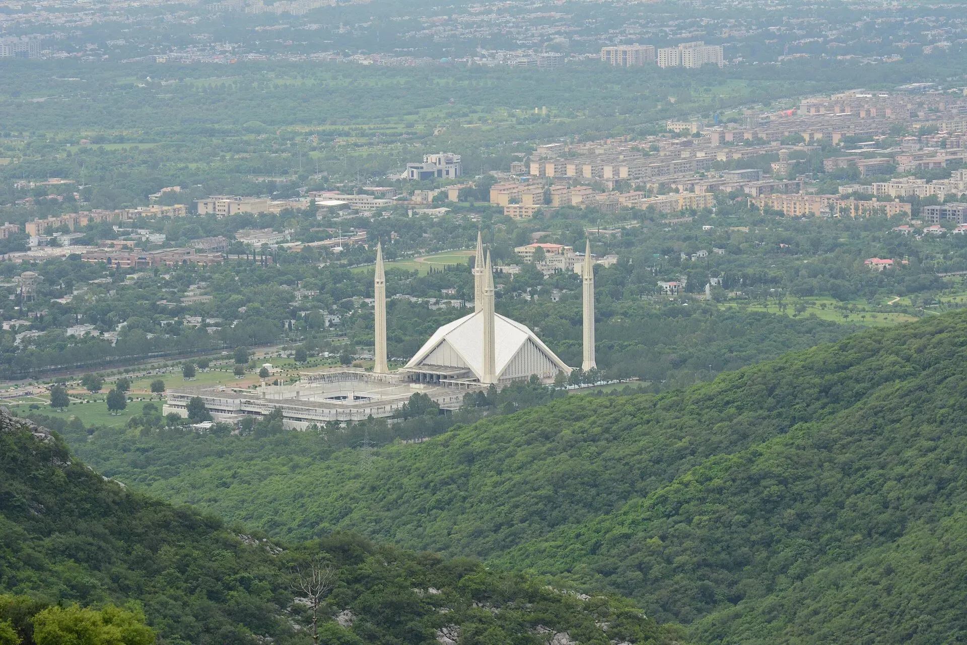
- Faisal Mosque stands at the foot of the hills, at the north end of Faisal Avenue. The Turkish architect Vedat Dalokay won an international competition for the design in 1969. Saudi Arabia funded the building, which began in 1976, and the first prayer was held in 1988. It has no dome. Its eight-sided, sloping roofs are modelled on a Bedouin tent, and four minarets of 90 m rise at the corners. Sources give different capacities, from about 10,000 in the main hall to tens of thousands with the courtyards.
- Pakistan Monument, completed in 2007, has petal-shaped walls with murals of Pakistani landmarks. A small museum is attached (Pakistan Monument Museum).
- Lok Virsa Heritage Museum, near Shakarparian, shows folk costume, jewellery, musical instruments and crafts from across the country.
- Islamabad Museum holds Gandhara-period relics, which blend Buddhist and Graeco-Roman styles, and the National Art Gallery stands near Parliament.
- Pakistan Museum of Natural History is mainly used for school visits.
- Bari Imam shrine at Nurpur Shahan draws large crowds for its annual urs (death-anniversary festival); more than 1.2 million people were reported in 2004.
- Golra Sharif Railway Museum keeps old locomotives and is a short ride from the city.
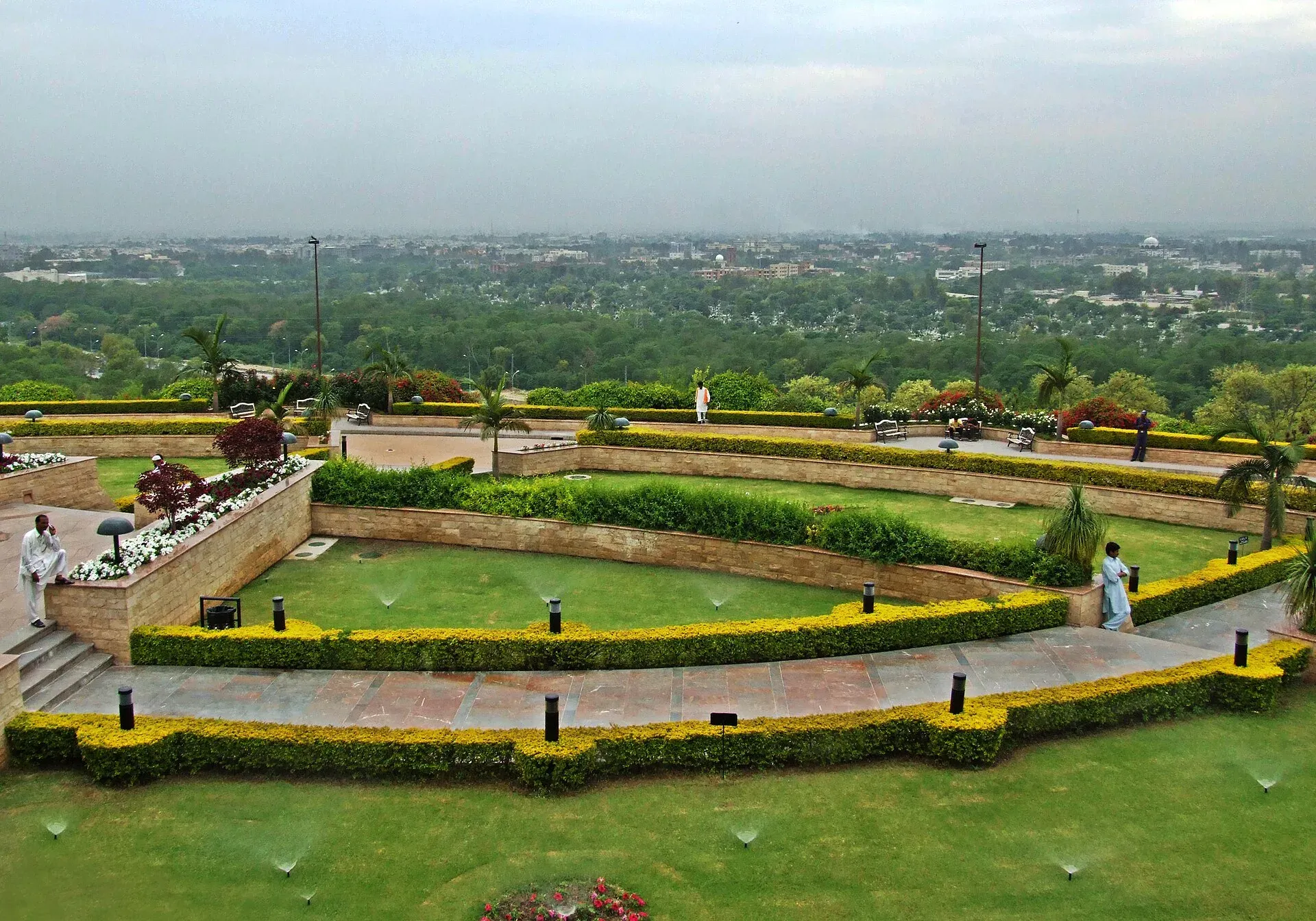
Photo: Amjad Sheikh, with thanks · CC BY-SA 3.0 · via Wikimedia Commons · temporary stand-in photo

Margalla Hills National Park
The park was established in 1980 and covers 17,386 hectares, which makes it the third-largest national park in Pakistan. It takes in the Margalla Hills, Rawal Lake and Shakarparian, and the Islamabad Wildlife Management Board runs it. The highest point is Tilla Charouni at 1,604 m. About 600 plant species grow here, among them chir pine and wild olive. Wildlife includes Indian leopard, grey goral (a small mountain antelope), barking deer and jungle cat. About 402 bird species have been recorded, among them the Himalayan vulture and peregrine falcon. Reptiles include Russell's viper and the Indian cobra.
There are seven numbered trails. Trail 3 is the city's oldest and most popular hike. It starts on Margalla Road at F-6/3 and takes roughly 1.5 to 2 hours to reach Pir Sohawa. Trail 5 is also busy, and Trail 7 leads to the Shah Allah Ditta caves. Start early (before about 07:30, or earlier in summer), carry water and wear sturdy shoes.
Viewpoints, lakes and parks
- Daman-e-Koh, above sector E-6, looks over the grid of the city, with Faisal Mosque easy to pick out. It is popular at sunset.
- Pir Sohawa is a hill viewpoint, reached on foot by Trail 3 or by a road of about 35 to 40 minutes.
- Rawal Lake and **Lake View Park** on its shore. The lake is fed by the Korang River and held back by the Rawal Dam.
- Fatima Jinnah Park in F-9 is a large city park with jogging paths.
- Shakarparian is a hilly green area south of G-6 and G-7, used for evening walks. The Lok Virsa museum and the Pakistan Monument are close by.
Older history around the city
Islamabad is new, but the land is old. The Potohar Plateau has some of the earliest known human sites in Asia, with Stone Age tools of about 100,000 to 500,000 years old. The Indus Valley civilisation flourished in the region from the 23rd to the 18th centuries BCE.
- Saidpur Village, at the foot of the hills, is a restored village that predates the city. It has small sacred ponds and a preserved temple, and today it is known for cafes and craft shops.
- Shah Allah Ditta caves are linked to an ancient Buddhist monastic community. A Buddhist stupa found at Ban Faqiran dates to the 2nd to 4th centuries CE.
- Pharwala Fort, by the Swaan stream, was built by the Gakhars in the 15th century, and Rawat Fort is also Gakhar work, from the 16th century.
- Taxila, the great Gandhara site, is a day trip away.
People, culture and food
The population is a mix of people from all over Pakistan, so Urdu, Punjabi, Pashto and English are all heard. Food is spread across the markaz (local market centre) of each sector. F-6 Super Market and F-7 Jinnah Super are the classic shopping and dining streets, and the Blue Area has more formal restaurants. G-9 Markaz has a reputation for street food, including Afghan-style kebabs, and the hill-side cafes at Saidpur and Daman-e-Koh suit an evening out. Shops near F-6 sell handicrafts, kilims and pashmina shawls; bargain politely. Nearby Rawalpindi is known for tikka, chana chaat and old bazaars like Raja Bazaar. Literary festivals, book fairs and craft markets are held through the year, and Lok Virsa hosts a heritage festival.
A day or two in Islamabad
One day. Walk or drive up to Daman-e-Koh in the morning, while the air is clear. Go on to Faisal Mosque, then spend the afternoon at the Pakistan Monument and Lok Virsa. End with dinner in F-6 or F-7.
Two days. Spend the first day as above. On the second, take Trail 3 early to Pir Sohawa, have lunch at Saidpur, and use the afternoon for Rawal Lake or a ride to Golra Sharif. A day trip to Taxila or Rawalpindi fits well if there is a third day.
When to go
February to April and September to November are the best months. May and June are hot (June highs routinely pass 38 degrees C), and July and August bring heavy monsoon rain. Winters are cool, with chilly nights and occasional fog, and the hills are clear and good for walks.
Getting around
Islamabad is spread out, so you will usually need a taxi, app ride or your own car. Agree a taxi fare before you set off. The Rawalpindi-Islamabad Metrobus opened its first phase on 4 June 2015 and links Pak Secretariat with Saddar in Rawalpindi. A Red Line, an Orange Line (to the airport) and Blue and Green Lines are listed, with the system running about 06:15 to 22:00. Check current timings before you rely on them. Trail heads are close enough to reach by car or ride from the sectors.
Permits and rules for visitors
- No permits are needed for the city or Margalla trails, though some trails and viewpoints have opening hours and may charge a small entry fee. Current fees will be added soon.
- Foreign visitors need a valid visa and may be asked to register or show documents at certain checkpoints. Carry your passport or a copy.
- Photography near government buildings, the diplomatic enclave and military sites may be restricted. Follow signs and security staff.
Safety
Islamabad is generally one of the safer cities, but security can tighten with little notice, especially for protests and major events in the Red Zone. Use ordinary city care. Avoid hiking alone or after dark, as leopards live in the hills and there have been reports of occasional crime on trails. Air pollution and monsoon flooding of low-lying roads can also occur.
Highlights
- Faisal Mosque and Daman-e-Koh viewpoint
- Margalla Hills trails and national park
- Lok Virsa and Pakistan Monument Museum
- Saidpur village and Rawal Lake
- Gateway to Murree, Swat and the Karakoram Highway
Getting there
By air. Islamabad International Airport (opened in 2018) is roughly 20 to 25 km from the centre and is the main entry point for the north.
By road. The M-2 motorway goes to Lahore (about 4 hours) and the M-1 to Peshawar (about 2 hours). The M-15 Hazara Motorway leads towards Abbottabad. The Karakoram Highway (N-35) starts at Hasan Abdal, about 50 km away.
By train. Rawalpindi is the nearest main station, with services across the country. Check Pakistan Railways for timetables.
In the city. The Rawalpindi-Islamabad Metrobus (about 24 km) links the two cities, and taxis and app-based services are plentiful.
Tips
- Hike Margalla trails early in the morning, and avoid them after dark.
- Carry water; monkeys and leopards live in the hills, so never feed wildlife.
- Dress modestly at Faisal Mosque and wait for prayer times to finish before entering.
- Rawalpindi is connected by metro bus and is worth a day trip for its bazaars.
- Check security notices for political gatherings in the Red Zone.
Sources and last checked
Last checked Confidence medium10 sources4 still to check
- Last checked
- Method
- Desk research from published sources
- Confidence
- medium
- Checked by
- trek.pk research team
Researched from published sources; not yet checked on the ground by our team. Spot something out of date? Report a mistake.
Sources
- Pakistan Tourism Guide 2021 · Trade Development Authority of Pakistan (TDAP) · checked
- Islamabad Capital Territory · Wikipedia · checked
- Margalla Hills National Park · Wikipedia · checked
- Capital Development Authority · Government of Pakistan · checked
- 2023 census of Pakistan (provincial populations) · Wikipedia · checked
- List of airports in Pakistan · Wikipedia · checked
- Islamabad Metrobus (Wikipedia) · Wikipedia · checked
- Islamabad · Wikipedia · checked
- Islamabad · Wikivoyage · checked
- Faisal Mosque · Wikipedia · checked
Still to be checked on the ground (4)
- Trail opening hours and entry fee arrangements (the park's manager is the Islamabad Wildlife Management Board; amounts not published here)
- Photography restrictions near sensitive buildings (no official source found)
- Faisal Mosque visiting hours and rules
- Current Metrobus timings and fares
Nearby and related

Islamabad
Pakistan's green, planned capital at the foot of the Margalla Hills: Faisal Mosque, hillside trails, cafes and the gateway to the north.

Margalla Hills National Park
The green hills above Islamabad: hiking trails, viewpoints, leopards and goral, a few minutes from the city centre. Established in 1980 and covering about 174 square kilometres.

Daman-e-Koh
A hilltop garden and lookout in the Margalla Hills, about 731 m up and 16 km by road from central Islamabad. It looks over the city's sectors, Faisal Mosque and Rawal Lake.

Faisal Mosque
Pakistan's national mosque, at the foot of the Margalla Hills in Islamabad. A tent-shaped hall with no dome and four 90 m minarets, open to respectful visitors outside prayer times.

Pakistan Monument
A petal-shaped national monument on Shakarparian Hill in Islamabad, opened in 2007, with a viewing platform over the city. The Pakistan Monument Museum stands beside it.

Lok Virsa Heritage Museum
Pakistan's national museum of ethnology on Shakarparian Hill, Islamabad, showing the crafts, costumes and living traditions of the country's peoples.

Saidpur Village
A restored Mughal-era village in a ravine of the Margalla Hills, with an old temple, a gurdwara, craft shops and cafes close to Daman-e-Koh.

Lake View Park
A CDA-run recreation park on the edge of Rawal Lake in Islamabad, with a large walk-in aviary, picnic lawns, a festival arena and boating on some days.

Bari Imam Shrine
The shrine of Bari Imam, the Sufi saint and patron of Islamabad, at Noorpur Shahan beneath the Margalla Hills. An active place of worship that welcomes respectful visitors of all faiths.

Shah Allah Ditta Caves
Rock shelters at the foot of the Margalla Hills in Islamabad, linked to Buddhist-era use and later to Hindu and Muslim ascetics. A short stop beside a small shrine and the start of the Margalla Ridge Trail.

Pir Sohawa
A hill-top spot on the Margalla Hills at about 914 m, 22 km by road from central Islamabad. It is a lookout, a trailhead and a cafe stop above the city.

Pakistan Monument Museum
A history museum beside the Pakistan Monument on Shakarparian Hill, Islamabad, run by Lok Virsa. It tells the story from ancient civilisations to the creation of Pakistan.

Pakistan Museum of Natural History
Islamabad's natural history museum on Shakarparian Hill: fossils, gemstones, wildlife, a whale skeleton and Pakistan's geology, in a research museum founded in 1976.

Fatima Jinnah Park
A very large public park filling Sector F-9 in Islamabad, also called F-9 Park or Capital Park. Walking tracks, lawns and quiet wooded areas, run by the Capital Development Authority.

Pharwala Fort
A ruined Gakhar fort above the Soan River, about 35 to 40 km from Rawalpindi. Added to Pakistan's UNESCO tentative list in 2026. Access is rough and the site is still fragile.
Rawat Fort, Rawalpindi
A fortified caravanserai on the Grand Trunk Road about 17 km east of Rawalpindi, founded in the 15th century and turned into a Gakhar stronghold in the 16th. On Pakistan's UNESCO tentative list since 2026.

Taxila
The ruins of several ancient cities and Buddhist monasteries near Islamabad, inscribed by UNESCO in 1980. Taxila was a crossroads of Gandhara, Greek, Persian and Kushan culture, with a fine museum.

Rawalpindi
Islamabad's older twin city: a busy bazaar and cantonment, the north's main rail and bus hub, and an easy base for Taxila and Murree.

Raja Bazaar (Rawalpindi)
The crowded wholesale and retail heart of old Rawalpindi: a web of lanes around Fawara Chowk selling cloth, spices, jewellery, books and household goods.

Murree
Hill resort and district capital at about 2,300 m in the Galyat hills above Islamabad. Mall Road, viewpoints, cool summers and winter snow; busy at weekends.

M-2 Islamabad-Lahore Motorway
Pakistan's first long motorway, the 375 km M-2, links Islamabad and Lahore across the Salt Range. It has over 20 interchanges, five pairs of service areas and fog closures in winter.

N-35 Karakoram Highway: Hasan Abdal-Khunjerab
The Karakoram Highway runs from Hasan Abdal through Hazara, Kohistan, Gilgit and Hunza to Khunjerab Pass (4,714 m) and China. Landslides are frequent and the UK advises against travel between Mansehra and Chilas.